array:2 [
"RF Query: /Property?$select=ALL&$top=20&$filter=ListingKey eq 1074960951/Property?$select=ALL&$top=20&$filter=ListingKey eq 1074960951&$expand=Media/Property?$select=ALL&$top=20&$filter=ListingKey eq 1074960951/Property?$select=ALL&$top=20&$filter=ListingKey eq 1074960951&$expand=Media&$count=true" => array:2 [
"RF Response" => Realtyna\MlsOnTheFly\Components\CloudPost\SubComponents\RFClient\SDK\RF\RFResponse {#4012
+items: array:1 [
0 => Realtyna\MlsOnTheFly\Components\CloudPost\SubComponents\RFClient\SDK\RF\Entities\RFProperty {#4010
+post_id: "53811"
+post_author: 1
+"ListingKey": "1074960951"
+"ListingId": "FR24092571"
+"PropertyType": "Land"
+"PropertySubType": "Water Position With Land"
+"StandardStatus": "Closed"
+"ModificationTimestamp": "2024-08-22T00:06:46Z"
+"RFModificationTimestamp": "2024-08-22T01:29:48.133639+00:00"
+"ListPrice": 274900.0
+"BathroomsTotalInteger": 0
+"BathroomsHalf": 0
+"BedroomsTotal": 0
+"LotSizeArea": 15.51
+"LivingArea": 0
+"BuildingAreaTotal": 0
+"City": "North Fork"
+"PostalCode": "93643"
+"UnparsedAddress": "32485 Road 228, North Fork, California 93643"
+"Coordinates": array:2 [
0 => -119.499112
1 => 37.219414
]
+"Latitude": 37.219414
+"Longitude": -119.499112
+"YearBuilt": 0
+"InternetAddressDisplayYN": true
+"FeedTypes": "IDX"
+"ListAgentFullName": "Kirsten Englund"
+"ListOfficeName": "Bass Lake Realty"
+"ListAgentMlsId": "YGkenglund"
+"ListOfficeMlsId": "fr81719"
+"OriginatingSystemName": "CRMLS"
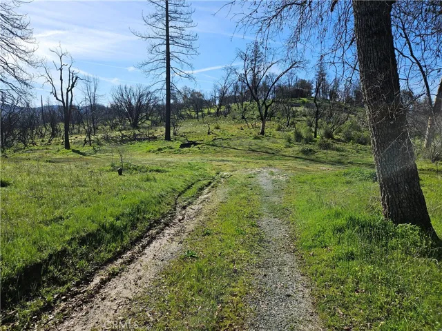
+"PublicRemarks": "Beautiful acreage in North Fork, bordering USFS property with the South Fork of the Willow Creek running through it. Two blocks down a country dirt road, and just a short distance to shops in North Fork & the North Fork Elementary School, this property burned in the 2022 Fork Fire, destroying 2 homes, the garden house and the shop. The fire burned hot in some areas and less so in others, meaning the 20 gpm well with pressure tank, 2 septic tanks, 2 electrical panels, and the ground-mounted solar-tracking array survived intact, ready for rebuilding without much site prep. The property has a clearance from the county certifying the building sites have met County standards for clean-up. There's no denying that many of the burned trees still need to be cleared, but that can be done over time, and the standing Ponderosa pines may offer good lumber when milled. Many trees have survived, including much of the fenced orchard & garden area, and some of the trees that didn't survive are already stump sprouting. The roads on the property have recently been graded. The lovely creek has year-round water, and the rolling land goes down to a more level area near the creek. Beautiful views abound from the hilltop, including snow capped mountain views to the north in winter, and sweeping views of the mountain range to the east. There's even a small peek of the golden pagoda at a nearby meditation center. Located very close to the Sierra Vista Scenic Byway, 20 minutes to Bass Lake, about 45 minutes to the South Gate of Yosemite Nat. Park, and less than an hour to Yosemite International Airport in Fresno, this property can be reached easily with so much to do nearby. Make your dreams for building a home, a retreat, a mini-ranch, vacation rentals, or whatever... come true. Best of all, the Sellers are willing to carry a note for an approved Buyer."
+"AttributionContact": "559-676-1901"
+"BuyerAgentAOR": "Fresno"
+"BuyerAgentDirectPhone": "559-432-5533"
+"BuyerAgentEmail": "KirstenEnglund@gmail.com"
+"BuyerAgentFirstName": "Kirsten"
+"BuyerAgentFullName": "Kirsten Englund"
+"BuyerAgentKey": "17046638"
+"BuyerAgentKeyNumeric": "17046638"
+"BuyerAgentLastName": "Englund"
+"BuyerAgentMlsId": "YGkenglund"
+"BuyerAgentStateLicense": "01307417"
+"BuyerAgentURL": "MtHomesByKirsten@KWRealty.com"
+"BuyerBrokerageCompensation": "3.000"
+"BuyerBrokerageCompensationType": "%"
+"BuyerFinancing": "Seller Financing"
+"BuyerOfficeAOR": "Fresno"
+"BuyerOfficeKey": "3244053"
+"BuyerOfficeKeyNumeric": "3244053"
+"BuyerOfficeMlsId": "fr81719"
+"BuyerOfficeName": "Bass Lake Realty"
+"BuyerOfficePhone": "559-642-3610"
+"BuyerOfficeURL": "basslakerealty.com"
+"CLIP": 5560956677
+"CloseDate": "2024-08-12"
+"ClosePrice": 272800.0
+"CommonInterest": "None"
+"CommunityFeatures": "Fishing,Hiking,Horse Trails,Hunting,Mountainous,Near National Forest,Park,Preserve/Public Land"
+"ContractStatusChangeDate": "2024-08-12"
+"Country": "US"
+"CountyOrParish": "Madera"
+"CreationDate": "2024-05-08T12:20:01.729353+00:00"
+"CumulativeDaysOnMarket": 39
+"CurrentFinancing": "None"
+"CurrentUse": "Unimproved"
+"DaysOnMarket": 39
+"DaysOnMarketReplication": 39
+"DaysOnMarketReplicationDate": "2024-08-22"
+"Directions": "From Oakhurst, take 41 N to R on Road 222, which turns into Rd 274, go straight to the traffic circle onto Rd 228 (2nd R). Go past cemetery, dogleg around the old barn stay to R past Goodwin's Lumber. Property is on L at end of Rd."
+"Disclosures": "Easement(s)"
+"DistanceToBusComments": "1 mile"
+"DistanceToElectricComments": "on site"
+"DistanceToSchoolsComments": "1 mile, 20 mile"
+"DistanceToShoppingComments": "1 mile"
+"DistanceToStreetComments": "at property"
+"DistanceToWaterComments": "on site"
+"DocumentsChangeTimestamp": "2024-05-08T04:59:54Z"
+"DocumentsCount": 3
+"Electric": "Photovoltaics on Grid,Photovoltaics Stand-Alone,Photovoltaics Seller Owned"
+"ElevationUnits": "Feet"
+"Exclusions": "Leased propane tanks, waiting to be removed by owner."
+"Fencing": "Cross Fenced,Goat Type,Needs Repair,Wire"
+"HorseAmenities": "Riding Trail"
+"HorseYN": true
+"Inclusions": "Well, solar system, 2 septic systems, 2 electrical panels, brick pizza oven."
+"InternetAutomatedValuationDisplayYN": true
+"InternetConsumerCommentYN": true
+"InternetEntireListingDisplayYN": true
+"ListAgentAOR": "Fresno"
+"ListAgentDirectPhone": "559-432-5533"
+"ListAgentEmail": "KirstenEnglund@gmail.com"
+"ListAgentFirstName": "Kirsten"
+"ListAgentKey": "17046638"
+"ListAgentKeyNumeric": "17046638"
+"ListAgentLastName": "Englund"
+"ListAgentOfficePhone": "559-642-3610"
+"ListAgentStateLicense": "01307417"
+"ListAgentURL": "MtHomesByKirsten@KWRealty.com"
+"ListOfficeAOR": "Fresno"
+"ListOfficeFax": "559-642-2771"
+"ListOfficeKey": "3244053"
+"ListOfficeKeyNumeric": "3244053"
+"ListOfficePhone": "559-642-3610"
+"ListOfficeURL": "basslakerealty.com"
+"ListingAgreement": "Exclusive Right To Sell"
+"ListingContractDate": "2024-05-08"
+"ListingKeyNumeric": 1074960951
+"ListingService": "Full Service"
+"ListingTerms": "Cash,Conventional,Owner Will Carry"
+"LotFeatures": "Gentle Sloping,Horse Property,Rolling Slope,Steep Slope,Sloped Up"
+"LotSizeAcres": 15.51
+"LotSizeSource": "Assessor"
+"LotSizeSquareFeet": 675615.6
+"MLSAreaMajor": "YG50 - North Fork"
+"MajorChangeTimestamp": "2024-08-13T18:02:48Z"
+"MajorChangeType": "Closed"
+"MlsStatus": "Closed"
+"OffMarketDate": "2024-06-16"
+"OffMarketTimestamp": "2024-08-05T15:17:10Z"
+"OnMarketDate": "2024-05-08"
+"OnMarketTimestamp": "2024-05-08T04:50:09Z"
+"OriginalEntryTimestamp": "2024-05-08T04:50:09Z"
+"OriginalListPrice": 274900.0
+"OriginatingSystemID": "CRM"
+"OriginatingSystemKey": "372738329"
+"OriginatingSystemSubName": "CRMLS_CRM"
+"ParcelNumber": "060180036"
+"PhotosChangeTimestamp": "2024-05-08T23:34:42Z"
+"PhotosCount": 47
+"PossibleUse": "Agricultural,Horses,Residential"
+"PostalCodePlus4": "9678"
+"PropertySubTypeAdditional": "Water Position With Land"
+"PurchaseContractDate": "2024-06-16"
+"RoadFrontageType": "Private Road"
+"RoadSurfaceType": "Unimproved"
+"Sewer": "Septic Tank"
+"ShowingContactName": "Kirsten Englund"
+"ShowingContactPhone": "559.676.1901"
+"ShowingContactType": "Agent,See Remarks"
+"SignOnPropertyYN": true
+"SourceSystemID": "TRESTLE"
+"SourceSystemKey": "1074960951"
+"SpecialListingConditions": "Standard"
+"StateOrProvince": "CA"
+"StatusChangeTimestamp": "2024-08-13T18:02:48Z"
+"StreetName": "Road 228"
+"StreetNumber": "32485"
+"StreetNumberNumeric": "32485"
+"TaxAnnualAmount": "2530.0"
+"UniversalPropertyId": "US-06039-N-060180036-R-N"
+"Utilities": "Electricity Available,Propane,Water Available,Overhead Utilities"
+"View": "Hills,Meadow,Mountain(s),Rocks,Creek/Stream,Trees/Woods"
+"ViewYN": true
+"VirtualTourURLBranded": "https://www.tourfactory.com/3141246"
+"VirtualTourURLUnbranded": "https://www.tourfactory.com/idxr3141246"
+"WaterSource": "Well"
+"WaterfrontFeatures": "Creek"
+"Zoning": "-RM"
+"CustomFields": array:4 [
"ListingKey" => "1074960951"
"AdminUpdateYN" => "0"
"ConcessionInPrice" => ""
"ConcessionInPriceType" => ""
]
+"TaxAuthority": "83-001"
+"IDXContactInfo": "559-676-1901"
+"HumanModifiedYN": false
+"LeaseAmountPerAreaUnit": "Dollars Per Square Foot"
+"@odata.id": "https://api.realtyfeed.com/reso/odata/Property('1074960951')"
+"CurrentPrice": 272800.0
+"provider_name": "CRMLS"
+"OriginatingSystemListOfficeKey": "152193917"
+"OriginatingSystemBuyerOfficeKey": "152193917"
+"OriginatingSystemListAgentMemberKey": "436734"
+"OriginatingSystemBuyerAgentMemberKey": "436734"
+"Media": array:47 [
0 => array:54 [
"Order" => 1
"ImageOf" => null
"ListAOR" => null
"MediaKey" => "2003246582466"
"MediaURL" => "https://dx41nk9nsacii.cloudfront.net/cdn/3/1074960951/637c61d8fa3f4ca8da4749b2c85309fb.webp"
"ClassName" => null
"MediaHTML" => null
"MediaSize" => 493113
"MediaType" => "webp"
"Thumbnail" => "https://dx41nk9nsacii.cloudfront.net/cdn/3/1074960951/thumbnail-637c61d8fa3f4ca8da4749b2c85309fb.webp"
"ImageWidth" => null
"Permission" => null
"ImageHeight" => null
"MediaStatus" => null
"SyndicateTo" => null
"ListAgentKey" => "17046638"
"PropertyType" => "Land"
"ResourceName" => "Property"
"ListOfficeKey" => "3244053"
"MediaCategory" => null
"MediaObjectID" => "001_Developed 15+ Acre Creek Parcel.jpg"
"OffMarketDate" => null
"X_MediaStream" => null
"SourceSystemID" => "TRESTLE"
"StandardStatus" => "Active"
"HumanModifiedYN" => false
"ListOfficeMlsId" => "fr81719"
"LongDescription" => null
"MediaKeyNumeric" => 2003246582466
"PropertySubType" => "Water Position With Land"
"PreferredPhotoYN" => null
"ResourceRecordID" => "FR24092571"
"ShortDescription" => null
"SourceSystemName" => null
"ChangedByMemberID" => null
"ListingPermission" => null
"PermissionPrivate" => null
"ResourceRecordKey" => "1074960951"
"ChangedByMemberKey" => null
"MediaClassification" => "PHOTO"
"OriginatingSystemID" => "CRM"
"ImageSizeDescription" => null
"SourceSystemMediaKey" => null
"ModificationTimestamp" => "2024-05-08T23:33:42.000-00:00"
"OriginatingSystemName" => "CRMLS"
"OriginatingSystemSubName" => "CRMLS_CRM"
"ResourceRecordKeyNumeric" => 1074960951
"ChangedByMemberKeyNumeric" => null
"OriginatingSystemMediaKey" => "372738329"
"PropertySubTypeAdditional" => "Water Position With Land"
"MediaModificationTimestamp" => "2024-05-08T23:33:42.000-00:00"
"InternetEntireListingDisplayYN" => true
"OriginatingSystemResourceRecordId" => null
"OriginatingSystemResourceRecordKey" => "372738329"
]
1 => array:54 [
"Order" => 2
"ImageOf" => null
"ListAOR" => null
"MediaKey" => "2003246582380"
"MediaURL" => "https://dx41nk9nsacii.cloudfront.net/cdn/3/1074960951/e1008130344886a29d82487c9f76d9af.webp"
"ClassName" => null
"MediaHTML" => null
"MediaSize" => 407208
"MediaType" => "webp"
"Thumbnail" => "https://dx41nk9nsacii.cloudfront.net/cdn/3/1074960951/thumbnail-e1008130344886a29d82487c9f76d9af.webp"
"ImageWidth" => null
"Permission" => null
"ImageHeight" => null
"MediaStatus" => null
"SyndicateTo" => null
"ListAgentKey" => "17046638"
"PropertyType" => "Land"
"ResourceName" => "Property"
"ListOfficeKey" => "3244053"
"MediaCategory" => null
"MediaObjectID" => "002_Gravel Drive up to the 2 Pads.jpg"
"OffMarketDate" => null
"X_MediaStream" => null
"SourceSystemID" => "TRESTLE"
"StandardStatus" => "Active"
"HumanModifiedYN" => false
"ListOfficeMlsId" => "fr81719"
"LongDescription" => null
"MediaKeyNumeric" => 2003246582380
"PropertySubType" => "Water Position With Land"
"PreferredPhotoYN" => null
"ResourceRecordID" => "FR24092571"
"ShortDescription" => null
"SourceSystemName" => null
"ChangedByMemberID" => null
"ListingPermission" => null
"PermissionPrivate" => null
"ResourceRecordKey" => "1074960951"
"ChangedByMemberKey" => null
"MediaClassification" => "PHOTO"
"OriginatingSystemID" => "CRM"
"ImageSizeDescription" => null
"SourceSystemMediaKey" => null
"ModificationTimestamp" => "2024-05-08T23:33:42.000-00:00"
"OriginatingSystemName" => "CRMLS"
"OriginatingSystemSubName" => "CRMLS_CRM"
"ResourceRecordKeyNumeric" => 1074960951
"ChangedByMemberKeyNumeric" => null
"OriginatingSystemMediaKey" => "372738329"
"PropertySubTypeAdditional" => "Water Position With Land"
"MediaModificationTimestamp" => "2024-05-08T23:33:42.000-00:00"
"InternetEntireListingDisplayYN" => true
"OriginatingSystemResourceRecordId" => null
"OriginatingSystemResourceRecordKey" => "372738329"
]
2 => array:54 [
"Order" => 3
"ImageOf" => null
"ListAOR" => null
"MediaKey" => "2003246582262"
"MediaURL" => "https://dx41nk9nsacii.cloudfront.net/cdn/3/1074960951/623d4974908f89870f97e210d8e2e1da.webp"
"ClassName" => null
"MediaHTML" => null
"MediaSize" => 501843
"MediaType" => "webp"
"Thumbnail" => "https://dx41nk9nsacii.cloudfront.net/cdn/3/1074960951/thumbnail-623d4974908f89870f97e210d8e2e1da.webp"
"ImageWidth" => null
"Permission" => null
"ImageHeight" => null
"MediaStatus" => null
"SyndicateTo" => null
"ListAgentKey" => "17046638"
"PropertyType" => "Land"
"ResourceName" => "Property"
"ListOfficeKey" => "3244053"
"MediaCategory" => null
"MediaObjectID" => "003_Dirt Road to Lower Pad for ADU.jpg"
"OffMarketDate" => null
"X_MediaStream" => null
"SourceSystemID" => "TRESTLE"
"StandardStatus" => "Active"
"HumanModifiedYN" => false
"ListOfficeMlsId" => "fr81719"
"LongDescription" => null
"MediaKeyNumeric" => 2003246582262
"PropertySubType" => "Water Position With Land"
"PreferredPhotoYN" => null
"ResourceRecordID" => "FR24092571"
"ShortDescription" => null
"SourceSystemName" => null
"ChangedByMemberID" => null
"ListingPermission" => null
"PermissionPrivate" => null
"ResourceRecordKey" => "1074960951"
"ChangedByMemberKey" => null
"MediaClassification" => "PHOTO"
"OriginatingSystemID" => "CRM"
"ImageSizeDescription" => null
"SourceSystemMediaKey" => null
"ModificationTimestamp" => "2024-05-08T23:33:42.000-00:00"
"OriginatingSystemName" => "CRMLS"
"OriginatingSystemSubName" => "CRMLS_CRM"
"ResourceRecordKeyNumeric" => 1074960951
"ChangedByMemberKeyNumeric" => null
"OriginatingSystemMediaKey" => "372738329"
"PropertySubTypeAdditional" => "Water Position With Land"
"MediaModificationTimestamp" => "2024-05-08T23:33:42.000-00:00"
"InternetEntireListingDisplayYN" => true
"OriginatingSystemResourceRecordId" => null
"OriginatingSystemResourceRecordKey" => "372738329"
]
3 => array:54 [
"Order" => 4
"ImageOf" => null
"ListAOR" => null
"MediaKey" => "2003246582303"
"MediaURL" => "https://dx41nk9nsacii.cloudfront.net/cdn/3/1074960951/0bb1ae62d0bcbf54a674646e28568427.webp"
"ClassName" => null
"MediaHTML" => null
"MediaSize" => 535054
"MediaType" => "webp"
"Thumbnail" => "https://dx41nk9nsacii.cloudfront.net/cdn/3/1074960951/thumbnail-0bb1ae62d0bcbf54a674646e28568427.webp"
"ImageWidth" => null
"Permission" => null
"ImageHeight" => null
"MediaStatus" => null
"SyndicateTo" => null
"ListAgentKey" => "17046638"
"PropertyType" => "Land"
"ResourceName" => "Property"
"ListOfficeKey" => "3244053"
"MediaCategory" => null
"MediaObjectID" => "004_Blossoming Fruit Trees.jpg"
"OffMarketDate" => null
"X_MediaStream" => null
"SourceSystemID" => "TRESTLE"
"StandardStatus" => "Active"
"HumanModifiedYN" => false
"ListOfficeMlsId" => "fr81719"
"LongDescription" => null
"MediaKeyNumeric" => 2003246582303
"PropertySubType" => "Water Position With Land"
"PreferredPhotoYN" => null
"ResourceRecordID" => "FR24092571"
"ShortDescription" => null
"SourceSystemName" => null
"ChangedByMemberID" => null
"ListingPermission" => null
"PermissionPrivate" => null
"ResourceRecordKey" => "1074960951"
"ChangedByMemberKey" => null
"MediaClassification" => "PHOTO"
"OriginatingSystemID" => "CRM"
"ImageSizeDescription" => null
"SourceSystemMediaKey" => null
"ModificationTimestamp" => "2024-05-08T23:33:42.000-00:00"
"OriginatingSystemName" => "CRMLS"
"OriginatingSystemSubName" => "CRMLS_CRM"
"ResourceRecordKeyNumeric" => 1074960951
"ChangedByMemberKeyNumeric" => null
"OriginatingSystemMediaKey" => "372738329"
"PropertySubTypeAdditional" => "Water Position With Land"
"MediaModificationTimestamp" => "2024-05-08T23:33:42.000-00:00"
"InternetEntireListingDisplayYN" => true
"OriginatingSystemResourceRecordId" => null
"OriginatingSystemResourceRecordKey" => "372738329"
]
4 => array:54 [
"Order" => 5
"ImageOf" => null
"ListAOR" => null
"MediaKey" => "2003246582221"
"MediaURL" => "https://dx41nk9nsacii.cloudfront.net/cdn/3/1074960951/bef0939387a4142047a3fc2501e092c4.webp"
"ClassName" => null
"MediaHTML" => null
"MediaSize" => 275957
"MediaType" => "webp"
"Thumbnail" => "https://dx41nk9nsacii.cloudfront.net/cdn/3/1074960951/thumbnail-bef0939387a4142047a3fc2501e092c4.webp"
"ImageWidth" => null
"Permission" => null
"ImageHeight" => null
"MediaStatus" => null
"SyndicateTo" => null
"ListAgentKey" => "17046638"
"PropertyType" => "Land"
"ResourceName" => "Property"
"ListOfficeKey" => "3244053"
"MediaCategory" => null
"MediaObjectID" => "005_Another View of the Orchard.jpg"
"OffMarketDate" => null
"X_MediaStream" => null
"SourceSystemID" => "TRESTLE"
"StandardStatus" => "Active"
"HumanModifiedYN" => false
"ListOfficeMlsId" => "fr81719"
"LongDescription" => null
"MediaKeyNumeric" => 2003246582221
"PropertySubType" => "Water Position With Land"
"PreferredPhotoYN" => null
"ResourceRecordID" => "FR24092571"
"ShortDescription" => null
"SourceSystemName" => null
"ChangedByMemberID" => null
"ListingPermission" => null
"PermissionPrivate" => null
"ResourceRecordKey" => "1074960951"
"ChangedByMemberKey" => null
"MediaClassification" => "PHOTO"
"OriginatingSystemID" => "CRM"
"ImageSizeDescription" => null
"SourceSystemMediaKey" => null
"ModificationTimestamp" => "2024-05-08T23:33:42.000-00:00"
"OriginatingSystemName" => "CRMLS"
"OriginatingSystemSubName" => "CRMLS_CRM"
"ResourceRecordKeyNumeric" => 1074960951
"ChangedByMemberKeyNumeric" => null
"OriginatingSystemMediaKey" => "372738329"
"PropertySubTypeAdditional" => "Water Position With Land"
"MediaModificationTimestamp" => "2024-05-08T23:33:42.000-00:00"
"InternetEntireListingDisplayYN" => true
"OriginatingSystemResourceRecordId" => null
"OriginatingSystemResourceRecordKey" => "372738329"
]
5 => array:54 [
"Order" => 6
"ImageOf" => null
"ListAOR" => null
"MediaKey" => "2003246582333"
"MediaURL" => "https://dx41nk9nsacii.cloudfront.net/cdn/3/1074960951/282cb52131f51195a5f8bfeaab8d972b.webp"
"ClassName" => null
"MediaHTML" => null
"MediaSize" => 399660
"MediaType" => "webp"
"Thumbnail" => "https://dx41nk9nsacii.cloudfront.net/cdn/3/1074960951/thumbnail-282cb52131f51195a5f8bfeaab8d972b.webp"
"ImageWidth" => null
"Permission" => null
"ImageHeight" => null
"MediaStatus" => null
"SyndicateTo" => null
"ListAgentKey" => "17046638"
"PropertyType" => "Land"
"ResourceName" => "Property"
"ListOfficeKey" => "3244053"
"MediaCategory" => null
"MediaObjectID" => "006_The Grape Arbor.jpg"
"OffMarketDate" => null
"X_MediaStream" => null
"SourceSystemID" => "TRESTLE"
"StandardStatus" => "Active"
"HumanModifiedYN" => false
"ListOfficeMlsId" => "fr81719"
"LongDescription" => null
"MediaKeyNumeric" => 2003246582333
"PropertySubType" => "Water Position With Land"
"PreferredPhotoYN" => null
"ResourceRecordID" => "FR24092571"
"ShortDescription" => null
"SourceSystemName" => null
"ChangedByMemberID" => null
"ListingPermission" => null
"PermissionPrivate" => null
"ResourceRecordKey" => "1074960951"
"ChangedByMemberKey" => null
"MediaClassification" => "PHOTO"
"OriginatingSystemID" => "CRM"
"ImageSizeDescription" => null
"SourceSystemMediaKey" => null
"ModificationTimestamp" => "2024-05-08T23:33:42.000-00:00"
"OriginatingSystemName" => "CRMLS"
"OriginatingSystemSubName" => "CRMLS_CRM"
"ResourceRecordKeyNumeric" => 1074960951
"ChangedByMemberKeyNumeric" => null
"OriginatingSystemMediaKey" => "372738329"
"PropertySubTypeAdditional" => "Water Position With Land"
"MediaModificationTimestamp" => "2024-05-08T23:33:42.000-00:00"
"InternetEntireListingDisplayYN" => true
"OriginatingSystemResourceRecordId" => null
"OriginatingSystemResourceRecordKey" => "372738329"
]
6 => array:54 [
"Order" => 7
"ImageOf" => null
"ListAOR" => null
"MediaKey" => "2003246582197"
"MediaURL" => "https://dx41nk9nsacii.cloudfront.net/cdn/3/1074960951/91a393f2387a0c8cbb2e42041fd76a3c.webp"
"ClassName" => null
"MediaHTML" => null
"MediaSize" => 446224
"MediaType" => "webp"
"Thumbnail" => "https://dx41nk9nsacii.cloudfront.net/cdn/3/1074960951/thumbnail-91a393f2387a0c8cbb2e42041fd76a3c.webp"
"ImageWidth" => null
"Permission" => null
"ImageHeight" => null
"MediaStatus" => null
"SyndicateTo" => null
"ListAgentKey" => "17046638"
"PropertyType" => "Land"
"ResourceName" => "Property"
"ListOfficeKey" => "3244053"
"MediaCategory" => null
"MediaObjectID" => "007_Beautiful in Springtime!.jpg"
"OffMarketDate" => null
"X_MediaStream" => null
"SourceSystemID" => "TRESTLE"
"StandardStatus" => "Active"
"HumanModifiedYN" => false
"ListOfficeMlsId" => "fr81719"
"LongDescription" => null
"MediaKeyNumeric" => 2003246582197
"PropertySubType" => "Water Position With Land"
"PreferredPhotoYN" => null
"ResourceRecordID" => "FR24092571"
"ShortDescription" => null
"SourceSystemName" => null
"ChangedByMemberID" => null
"ListingPermission" => null
"PermissionPrivate" => null
"ResourceRecordKey" => "1074960951"
"ChangedByMemberKey" => null
"MediaClassification" => "PHOTO"
"OriginatingSystemID" => "CRM"
"ImageSizeDescription" => null
"SourceSystemMediaKey" => null
"ModificationTimestamp" => "2024-05-08T23:33:42.000-00:00"
"OriginatingSystemName" => "CRMLS"
"OriginatingSystemSubName" => "CRMLS_CRM"
"ResourceRecordKeyNumeric" => 1074960951
"ChangedByMemberKeyNumeric" => null
"OriginatingSystemMediaKey" => "372738329"
"PropertySubTypeAdditional" => "Water Position With Land"
"MediaModificationTimestamp" => "2024-05-08T23:33:42.000-00:00"
"InternetEntireListingDisplayYN" => true
"OriginatingSystemResourceRecordId" => null
"OriginatingSystemResourceRecordKey" => "372738329"
]
7 => array:54 [
"Order" => 8
"ImageOf" => null
"ListAOR" => null
"MediaKey" => "2003246582394"
"MediaURL" => "https://dx41nk9nsacii.cloudfront.net/cdn/3/1074960951/58abd58f972bda353f805fd699c5b5e3.webp"
"ClassName" => null
"MediaHTML" => null
"MediaSize" => 333214
"MediaType" => "webp"
"Thumbnail" => "https://dx41nk9nsacii.cloudfront.net/cdn/3/1074960951/thumbnail-58abd58f972bda353f805fd699c5b5e3.webp"
"ImageWidth" => null
"Permission" => null
"ImageHeight" => null
"MediaStatus" => null
"SyndicateTo" => null
"ListAgentKey" => "17046638"
"PropertyType" => "Land"
"ResourceName" => "Property"
"ListOfficeKey" => "3244053"
"MediaCategory" => null
"MediaObjectID" => "008_A View from the Orchard.jpg"
"OffMarketDate" => null
"X_MediaStream" => null
"SourceSystemID" => "TRESTLE"
"StandardStatus" => "Active"
"HumanModifiedYN" => false
"ListOfficeMlsId" => "fr81719"
"LongDescription" => null
"MediaKeyNumeric" => 2003246582394
"PropertySubType" => "Water Position With Land"
"PreferredPhotoYN" => null
"ResourceRecordID" => "FR24092571"
"ShortDescription" => null
"SourceSystemName" => null
"ChangedByMemberID" => null
"ListingPermission" => null
"PermissionPrivate" => null
"ResourceRecordKey" => "1074960951"
"ChangedByMemberKey" => null
"MediaClassification" => "PHOTO"
"OriginatingSystemID" => "CRM"
"ImageSizeDescription" => null
"SourceSystemMediaKey" => null
"ModificationTimestamp" => "2024-05-08T23:33:42.000-00:00"
"OriginatingSystemName" => "CRMLS"
"OriginatingSystemSubName" => "CRMLS_CRM"
"ResourceRecordKeyNumeric" => 1074960951
"ChangedByMemberKeyNumeric" => null
"OriginatingSystemMediaKey" => "372738329"
"PropertySubTypeAdditional" => "Water Position With Land"
"MediaModificationTimestamp" => "2024-05-08T23:33:42.000-00:00"
"InternetEntireListingDisplayYN" => true
"OriginatingSystemResourceRecordId" => null
"OriginatingSystemResourceRecordKey" => "372738329"
]
8 => array:54 [
"Order" => 9
"ImageOf" => null
"ListAOR" => null
"MediaKey" => "2003246582591"
"MediaURL" => "https://dx41nk9nsacii.cloudfront.net/cdn/3/1074960951/7eb19560aaf8d0ffa63f7b1c9e1b8089.webp"
"ClassName" => null
"MediaHTML" => null
"MediaSize" => 524806
"MediaType" => "webp"
"Thumbnail" => "https://dx41nk9nsacii.cloudfront.net/cdn/3/1074960951/thumbnail-7eb19560aaf8d0ffa63f7b1c9e1b8089.webp"
"ImageWidth" => null
"Permission" => null
"ImageHeight" => null
"MediaStatus" => null
"SyndicateTo" => null
"ListAgentKey" => "17046638"
"PropertyType" => "Land"
"ResourceName" => "Property"
"ListOfficeKey" => "3244053"
"MediaCategory" => null
"MediaObjectID" => "009_The Garden Beds."
"OffMarketDate" => null
"X_MediaStream" => null
"SourceSystemID" => "TRESTLE"
"StandardStatus" => "Active"
"HumanModifiedYN" => false
"ListOfficeMlsId" => "fr81719"
"LongDescription" => null
"MediaKeyNumeric" => 2003246582591
"PropertySubType" => "Water Position With Land"
"PreferredPhotoYN" => null
"ResourceRecordID" => "FR24092571"
"ShortDescription" => null
"SourceSystemName" => null
"ChangedByMemberID" => null
"ListingPermission" => null
"PermissionPrivate" => null
"ResourceRecordKey" => "1074960951"
"ChangedByMemberKey" => null
"MediaClassification" => "PHOTO"
"OriginatingSystemID" => "CRM"
"ImageSizeDescription" => null
"SourceSystemMediaKey" => null
"ModificationTimestamp" => "2024-05-08T23:33:42.000-00:00"
"OriginatingSystemName" => "CRMLS"
"OriginatingSystemSubName" => "CRMLS_CRM"
"ResourceRecordKeyNumeric" => 1074960951
"ChangedByMemberKeyNumeric" => null
"OriginatingSystemMediaKey" => "372738329"
"PropertySubTypeAdditional" => "Water Position With Land"
"MediaModificationTimestamp" => "2024-05-08T23:33:42.000-00:00"
"InternetEntireListingDisplayYN" => true
"OriginatingSystemResourceRecordId" => null
"OriginatingSystemResourceRecordKey" => "372738329"
]
9 => array:54 [
"Order" => 10
"ImageOf" => null
"ListAOR" => null
"MediaKey" => "2003246582382"
"MediaURL" => "https://dx41nk9nsacii.cloudfront.net/cdn/3/1074960951/4218287f5c6bf1b79f110650e46e6fb0.webp"
"ClassName" => null
"MediaHTML" => null
"MediaSize" => 363036
"MediaType" => "webp"
"Thumbnail" => "https://dx41nk9nsacii.cloudfront.net/cdn/3/1074960951/thumbnail-4218287f5c6bf1b79f110650e46e6fb0.webp"
"ImageWidth" => null
"Permission" => null
"ImageHeight" => null
"MediaStatus" => null
"SyndicateTo" => null
"ListAgentKey" => "17046638"
"PropertyType" => "Land"
"ResourceName" => "Property"
"ListOfficeKey" => "3244053"
"MediaCategory" => null
"MediaObjectID" => "010_A View of the Fenced Garden Area.jpg"
"OffMarketDate" => null
"X_MediaStream" => null
"SourceSystemID" => "TRESTLE"
"StandardStatus" => "Active"
"HumanModifiedYN" => false
"ListOfficeMlsId" => "fr81719"
"LongDescription" => null
"MediaKeyNumeric" => 2003246582382
"PropertySubType" => "Water Position With Land"
"PreferredPhotoYN" => null
"ResourceRecordID" => "FR24092571"
"ShortDescription" => null
"SourceSystemName" => null
"ChangedByMemberID" => null
"ListingPermission" => null
"PermissionPrivate" => null
"ResourceRecordKey" => "1074960951"
"ChangedByMemberKey" => null
"MediaClassification" => "PHOTO"
"OriginatingSystemID" => "CRM"
"ImageSizeDescription" => null
"SourceSystemMediaKey" => null
"ModificationTimestamp" => "2024-05-08T23:33:42.000-00:00"
"OriginatingSystemName" => "CRMLS"
"OriginatingSystemSubName" => "CRMLS_CRM"
"ResourceRecordKeyNumeric" => 1074960951
"ChangedByMemberKeyNumeric" => null
"OriginatingSystemMediaKey" => "372738329"
"PropertySubTypeAdditional" => "Water Position With Land"
"MediaModificationTimestamp" => "2024-05-08T23:33:42.000-00:00"
"InternetEntireListingDisplayYN" => true
"OriginatingSystemResourceRecordId" => null
"OriginatingSystemResourceRecordKey" => "372738329"
]
10 => array:54 [
"Order" => 11
"ImageOf" => null
"ListAOR" => null
"MediaKey" => "2003246582330"
"MediaURL" => "https://dx41nk9nsacii.cloudfront.net/cdn/3/1074960951/8c5de831e38468e95bd9b681d0cb1a36.webp"
"ClassName" => null
"MediaHTML" => null
"MediaSize" => 399576
"MediaType" => "webp"
"Thumbnail" => "https://dx41nk9nsacii.cloudfront.net/cdn/3/1074960951/thumbnail-8c5de831e38468e95bd9b681d0cb1a36.webp"
"ImageWidth" => null
"Permission" => null
"ImageHeight" => null
"MediaStatus" => null
"SyndicateTo" => null
"ListAgentKey" => "17046638"
"PropertyType" => "Land"
"ResourceName" => "Property"
"ListOfficeKey" => "3244053"
"MediaCategory" => null
"MediaObjectID" => "011_Many of the Oaks are Greening Up.jpg"
"OffMarketDate" => null
"X_MediaStream" => null
"SourceSystemID" => "TRESTLE"
"StandardStatus" => "Active"
"HumanModifiedYN" => false
"ListOfficeMlsId" => "fr81719"
"LongDescription" => null
"MediaKeyNumeric" => 2003246582330
"PropertySubType" => "Water Position With Land"
"PreferredPhotoYN" => null
"ResourceRecordID" => "FR24092571"
"ShortDescription" => null
"SourceSystemName" => null
"ChangedByMemberID" => null
"ListingPermission" => null
"PermissionPrivate" => null
"ResourceRecordKey" => "1074960951"
"ChangedByMemberKey" => null
"MediaClassification" => "PHOTO"
"OriginatingSystemID" => "CRM"
"ImageSizeDescription" => null
"SourceSystemMediaKey" => null
"ModificationTimestamp" => "2024-05-08T23:33:42.000-00:00"
"OriginatingSystemName" => "CRMLS"
"OriginatingSystemSubName" => "CRMLS_CRM"
"ResourceRecordKeyNumeric" => 1074960951
"ChangedByMemberKeyNumeric" => null
"OriginatingSystemMediaKey" => "372738329"
"PropertySubTypeAdditional" => "Water Position With Land"
"MediaModificationTimestamp" => "2024-05-08T23:33:42.000-00:00"
"InternetEntireListingDisplayYN" => true
"OriginatingSystemResourceRecordId" => null
"OriginatingSystemResourceRecordKey" => "372738329"
]
11 => array:54 [
"Order" => 12
"ImageOf" => null
"ListAOR" => null
"MediaKey" => "2003246582498"
"MediaURL" => "https://dx41nk9nsacii.cloudfront.net/cdn/3/1074960951/33e8c24a81efd48cdcf89ca67f2de84b.webp"
"ClassName" => null
"MediaHTML" => null
"MediaSize" => 323912
"MediaType" => "webp"
"Thumbnail" => "https://dx41nk9nsacii.cloudfront.net/cdn/3/1074960951/thumbnail-33e8c24a81efd48cdcf89ca67f2de84b.webp"
"ImageWidth" => null
"Permission" => null
"ImageHeight" => null
"MediaStatus" => null
"SyndicateTo" => null
"ListAgentKey" => "17046638"
"PropertyType" => "Land"
"ResourceName" => "Property"
"ListOfficeKey" => "3244053"
"MediaCategory" => null
"MediaObjectID" => "012_One of the Gates wNearby Grapes.jpg"
"OffMarketDate" => null
"X_MediaStream" => null
"SourceSystemID" => "TRESTLE"
"StandardStatus" => "Active"
"HumanModifiedYN" => false
"ListOfficeMlsId" => "fr81719"
"LongDescription" => null
"MediaKeyNumeric" => 2003246582498
"PropertySubType" => "Water Position With Land"
"PreferredPhotoYN" => null
"ResourceRecordID" => "FR24092571"
"ShortDescription" => null
"SourceSystemName" => null
"ChangedByMemberID" => null
"ListingPermission" => null
"PermissionPrivate" => null
"ResourceRecordKey" => "1074960951"
"ChangedByMemberKey" => null
"MediaClassification" => "PHOTO"
"OriginatingSystemID" => "CRM"
"ImageSizeDescription" => null
"SourceSystemMediaKey" => null
"ModificationTimestamp" => "2024-05-08T23:33:42.000-00:00"
"OriginatingSystemName" => "CRMLS"
"OriginatingSystemSubName" => "CRMLS_CRM"
"ResourceRecordKeyNumeric" => 1074960951
"ChangedByMemberKeyNumeric" => null
"OriginatingSystemMediaKey" => "372738329"
"PropertySubTypeAdditional" => "Water Position With Land"
"MediaModificationTimestamp" => "2024-05-08T23:33:42.000-00:00"
"InternetEntireListingDisplayYN" => true
"OriginatingSystemResourceRecordId" => null
"OriginatingSystemResourceRecordKey" => "372738329"
]
12 => array:54 [
"Order" => 13
"ImageOf" => null
"ListAOR" => null
"MediaKey" => "2003246582462"
"MediaURL" => "https://dx41nk9nsacii.cloudfront.net/cdn/3/1074960951/15dbefe4854cd3fde56533a979c7c7d9.webp"
"ClassName" => null
"MediaHTML" => null
"MediaSize" => 294164
"MediaType" => "webp"
"Thumbnail" => "https://dx41nk9nsacii.cloudfront.net/cdn/3/1074960951/thumbnail-15dbefe4854cd3fde56533a979c7c7d9.webp"
"ImageWidth" => null
"Permission" => null
"ImageHeight" => null
"MediaStatus" => null
"SyndicateTo" => null
"ListAgentKey" => "17046638"
"PropertyType" => "Land"
"ResourceName" => "Property"
"ListOfficeKey" => "3244053"
"MediaCategory" => null
"MediaObjectID" => "013_Solar Panels Work Just Fine.jpg"
"OffMarketDate" => null
"X_MediaStream" => null
"SourceSystemID" => "TRESTLE"
"StandardStatus" => "Active"
"HumanModifiedYN" => false
"ListOfficeMlsId" => "fr81719"
"LongDescription" => null
"MediaKeyNumeric" => 2003246582462
"PropertySubType" => "Water Position With Land"
"PreferredPhotoYN" => null
"ResourceRecordID" => "FR24092571"
"ShortDescription" => null
"SourceSystemName" => null
"ChangedByMemberID" => null
"ListingPermission" => null
"PermissionPrivate" => null
"ResourceRecordKey" => "1074960951"
"ChangedByMemberKey" => null
"MediaClassification" => "PHOTO"
"OriginatingSystemID" => "CRM"
"ImageSizeDescription" => null
"SourceSystemMediaKey" => null
"ModificationTimestamp" => "2024-05-08T23:33:42.000-00:00"
"OriginatingSystemName" => "CRMLS"
"OriginatingSystemSubName" => "CRMLS_CRM"
"ResourceRecordKeyNumeric" => 1074960951
"ChangedByMemberKeyNumeric" => null
"OriginatingSystemMediaKey" => "372738329"
"PropertySubTypeAdditional" => "Water Position With Land"
"MediaModificationTimestamp" => "2024-05-08T23:33:42.000-00:00"
"InternetEntireListingDisplayYN" => true
"OriginatingSystemResourceRecordId" => null
"OriginatingSystemResourceRecordKey" => "372738329"
]
13 => array:54 [
"Order" => 14
"ImageOf" => null
"ListAOR" => null
"MediaKey" => "2003246582236"
"MediaURL" => "https://dx41nk9nsacii.cloudfront.net/cdn/3/1074960951/ee3c7b93cfadf71d85e4ac97f1f7edb8.webp"
"ClassName" => null
"MediaHTML" => null
"MediaSize" => 554654
"MediaType" => "webp"
"Thumbnail" => "https://dx41nk9nsacii.cloudfront.net/cdn/3/1074960951/thumbnail-ee3c7b93cfadf71d85e4ac97f1f7edb8.webp"
"ImageWidth" => null
"Permission" => null
"ImageHeight" => null
"MediaStatus" => null
"SyndicateTo" => null
"ListAgentKey" => "17046638"
"PropertyType" => "Land"
"ResourceName" => "Property"
"ListOfficeKey" => "3244053"
"MediaCategory" => null
"MediaObjectID" => "014_More Fruit Trees Leafing Out.jpg"
"OffMarketDate" => null
"X_MediaStream" => null
"SourceSystemID" => "TRESTLE"
"StandardStatus" => "Active"
"HumanModifiedYN" => false
"ListOfficeMlsId" => "fr81719"
"LongDescription" => null
"MediaKeyNumeric" => 2003246582236
"PropertySubType" => "Water Position With Land"
"PreferredPhotoYN" => null
"ResourceRecordID" => "FR24092571"
"ShortDescription" => null
"SourceSystemName" => null
"ChangedByMemberID" => null
"ListingPermission" => null
"PermissionPrivate" => null
"ResourceRecordKey" => "1074960951"
"ChangedByMemberKey" => null
"MediaClassification" => "PHOTO"
"OriginatingSystemID" => "CRM"
"ImageSizeDescription" => null
"SourceSystemMediaKey" => null
"ModificationTimestamp" => "2024-05-08T23:33:42.000-00:00"
"OriginatingSystemName" => "CRMLS"
"OriginatingSystemSubName" => "CRMLS_CRM"
"ResourceRecordKeyNumeric" => 1074960951
"ChangedByMemberKeyNumeric" => null
"OriginatingSystemMediaKey" => "372738329"
"PropertySubTypeAdditional" => "Water Position With Land"
"MediaModificationTimestamp" => "2024-05-08T23:33:42.000-00:00"
"InternetEntireListingDisplayYN" => true
"OriginatingSystemResourceRecordId" => null
"OriginatingSystemResourceRecordKey" => "372738329"
]
14 => array:54 [
"Order" => 15
"ImageOf" => null
"ListAOR" => null
"MediaKey" => "2003246582529"
"MediaURL" => "https://dx41nk9nsacii.cloudfront.net/cdn/3/1074960951/61953184e4766d9009eaaadf65db53fb.webp"
"ClassName" => null
"MediaHTML" => null
"MediaSize" => 485522
"MediaType" => "webp"
"Thumbnail" => "https://dx41nk9nsacii.cloudfront.net/cdn/3/1074960951/thumbnail-61953184e4766d9009eaaadf65db53fb.webp"
"ImageWidth" => null
"Permission" => null
"ImageHeight" => null
"MediaStatus" => null
"SyndicateTo" => null
"ListAgentKey" => "17046638"
"PropertyType" => "Land"
"ResourceName" => "Property"
"ListOfficeKey" => "3244053"
"MediaCategory" => null
"MediaObjectID" => "015_Upper Electrical Panel.jpg"
"OffMarketDate" => null
"X_MediaStream" => null
"SourceSystemID" => "TRESTLE"
"StandardStatus" => "Active"
"HumanModifiedYN" => false
"ListOfficeMlsId" => "fr81719"
"LongDescription" => null
"MediaKeyNumeric" => 2003246582529
"PropertySubType" => "Water Position With Land"
"PreferredPhotoYN" => null
"ResourceRecordID" => "FR24092571"
"ShortDescription" => null
"SourceSystemName" => null
"ChangedByMemberID" => null
"ListingPermission" => null
"PermissionPrivate" => null
"ResourceRecordKey" => "1074960951"
"ChangedByMemberKey" => null
"MediaClassification" => "PHOTO"
"OriginatingSystemID" => "CRM"
"ImageSizeDescription" => null
"SourceSystemMediaKey" => null
"ModificationTimestamp" => "2024-05-08T23:33:42.000-00:00"
"OriginatingSystemName" => "CRMLS"
"OriginatingSystemSubName" => "CRMLS_CRM"
"ResourceRecordKeyNumeric" => 1074960951
"ChangedByMemberKeyNumeric" => null
"OriginatingSystemMediaKey" => "372738329"
"PropertySubTypeAdditional" => "Water Position With Land"
"MediaModificationTimestamp" => "2024-05-08T23:33:42.000-00:00"
"InternetEntireListingDisplayYN" => true
"OriginatingSystemResourceRecordId" => null
"OriginatingSystemResourceRecordKey" => "372738329"
]
15 => array:54 [
"Order" => 16
"ImageOf" => null
"ListAOR" => null
"MediaKey" => "2003246582296"
"MediaURL" => "https://dx41nk9nsacii.cloudfront.net/cdn/3/1074960951/7b2515884a81dde77cc495dff3bd7b50.webp"
"ClassName" => null
"MediaHTML" => null
"MediaSize" => 416823
"MediaType" => "webp"
"Thumbnail" => "https://dx41nk9nsacii.cloudfront.net/cdn/3/1074960951/thumbnail-7b2515884a81dde77cc495dff3bd7b50.webp"
"ImageWidth" => null
"Permission" => null
"ImageHeight" => null
"MediaStatus" => null
"SyndicateTo" => null
"ListAgentKey" => "17046638"
"PropertyType" => "Land"
"ResourceName" => "Property"
"ListOfficeKey" => "3244053"
"MediaCategory" => null
"MediaObjectID" => "016_Lower Panel wSmart Meter.jpg"
"OffMarketDate" => null
"X_MediaStream" => null
"SourceSystemID" => "TRESTLE"
"StandardStatus" => "Active"
"HumanModifiedYN" => false
"ListOfficeMlsId" => "fr81719"
"LongDescription" => null
"MediaKeyNumeric" => 2003246582296
"PropertySubType" => "Water Position With Land"
"PreferredPhotoYN" => null
"ResourceRecordID" => "FR24092571"
"ShortDescription" => null
"SourceSystemName" => null
"ChangedByMemberID" => null
"ListingPermission" => null
"PermissionPrivate" => null
"ResourceRecordKey" => "1074960951"
"ChangedByMemberKey" => null
"MediaClassification" => "PHOTO"
"OriginatingSystemID" => "CRM"
"ImageSizeDescription" => null
"SourceSystemMediaKey" => null
"ModificationTimestamp" => "2024-05-08T23:33:42.000-00:00"
"OriginatingSystemName" => "CRMLS"
"OriginatingSystemSubName" => "CRMLS_CRM"
"ResourceRecordKeyNumeric" => 1074960951
"ChangedByMemberKeyNumeric" => null
"OriginatingSystemMediaKey" => "372738329"
"PropertySubTypeAdditional" => "Water Position With Land"
"MediaModificationTimestamp" => "2024-05-08T23:33:42.000-00:00"
"InternetEntireListingDisplayYN" => true
"OriginatingSystemResourceRecordId" => null
"OriginatingSystemResourceRecordKey" => "372738329"
]
16 => array:54 [
"Order" => 17
"ImageOf" => null
"ListAOR" => null
"MediaKey" => "2003246582193"
"MediaURL" => "https://dx41nk9nsacii.cloudfront.net/cdn/3/1074960951/7a21029380c5cf8f8934b8bc8aeee9ca.webp"
"ClassName" => null
"MediaHTML" => null
"MediaSize" => 460163
"MediaType" => "webp"
"Thumbnail" => "https://dx41nk9nsacii.cloudfront.net/cdn/3/1074960951/thumbnail-7a21029380c5cf8f8934b8bc8aeee9ca.webp"
"ImageWidth" => null
"Permission" => null
"ImageHeight" => null
"MediaStatus" => null
"SyndicateTo" => null
"ListAgentKey" => "17046638"
"PropertyType" => "Land"
"ResourceName" => "Property"
"ListOfficeKey" => "3244053"
"MediaCategory" => null
"MediaObjectID" => "017_Distant Views."
"OffMarketDate" => null
"X_MediaStream" => null
"SourceSystemID" => "TRESTLE"
"StandardStatus" => "Active"
"HumanModifiedYN" => false
"ListOfficeMlsId" => "fr81719"
"LongDescription" => null
"MediaKeyNumeric" => 2003246582193
"PropertySubType" => "Water Position With Land"
"PreferredPhotoYN" => null
"ResourceRecordID" => "FR24092571"
"ShortDescription" => null
"SourceSystemName" => null
"ChangedByMemberID" => null
"ListingPermission" => null
"PermissionPrivate" => null
"ResourceRecordKey" => "1074960951"
"ChangedByMemberKey" => null
"MediaClassification" => "PHOTO"
"OriginatingSystemID" => "CRM"
"ImageSizeDescription" => null
"SourceSystemMediaKey" => null
"ModificationTimestamp" => "2024-05-08T23:33:42.000-00:00"
"OriginatingSystemName" => "CRMLS"
"OriginatingSystemSubName" => "CRMLS_CRM"
"ResourceRecordKeyNumeric" => 1074960951
"ChangedByMemberKeyNumeric" => null
"OriginatingSystemMediaKey" => "372738329"
"PropertySubTypeAdditional" => "Water Position With Land"
"MediaModificationTimestamp" => "2024-05-08T23:33:42.000-00:00"
"InternetEntireListingDisplayYN" => true
"OriginatingSystemResourceRecordId" => null
"OriginatingSystemResourceRecordKey" => "372738329"
]
17 => array:54 [
"Order" => 18
"ImageOf" => null
"ListAOR" => null
"MediaKey" => "2003246582228"
"MediaURL" => "https://dx41nk9nsacii.cloudfront.net/cdn/3/1074960951/eaa667555f6cd56a9793725012b5e7a8.webp"
"ClassName" => null
"MediaHTML" => null
"MediaSize" => 414199
"MediaType" => "webp"
"Thumbnail" => "https://dx41nk9nsacii.cloudfront.net/cdn/3/1074960951/thumbnail-eaa667555f6cd56a9793725012b5e7a8.webp"
"ImageWidth" => null
"Permission" => null
"ImageHeight" => null
"MediaStatus" => null
"SyndicateTo" => null
"ListAgentKey" => "17046638"
"PropertyType" => "Land"
"ResourceName" => "Property"
"ListOfficeKey" => "3244053"
"MediaCategory" => null
"MediaObjectID" => "018_Snow-capped View from Upper Pad.jpg"
"OffMarketDate" => null
"X_MediaStream" => null
"SourceSystemID" => "TRESTLE"
"StandardStatus" => "Active"
"HumanModifiedYN" => false
"ListOfficeMlsId" => "fr81719"
"LongDescription" => null
"MediaKeyNumeric" => 2003246582228
"PropertySubType" => "Water Position With Land"
"PreferredPhotoYN" => null
"ResourceRecordID" => "FR24092571"
"ShortDescription" => null
"SourceSystemName" => null
"ChangedByMemberID" => null
"ListingPermission" => null
"PermissionPrivate" => null
"ResourceRecordKey" => "1074960951"
"ChangedByMemberKey" => null
"MediaClassification" => "PHOTO"
"OriginatingSystemID" => "CRM"
"ImageSizeDescription" => null
"SourceSystemMediaKey" => null
"ModificationTimestamp" => "2024-05-08T23:33:42.000-00:00"
"OriginatingSystemName" => "CRMLS"
"OriginatingSystemSubName" => "CRMLS_CRM"
"ResourceRecordKeyNumeric" => 1074960951
"ChangedByMemberKeyNumeric" => null
"OriginatingSystemMediaKey" => "372738329"
"PropertySubTypeAdditional" => "Water Position With Land"
"MediaModificationTimestamp" => "2024-05-08T23:33:42.000-00:00"
"InternetEntireListingDisplayYN" => true
"OriginatingSystemResourceRecordId" => null
"OriginatingSystemResourceRecordKey" => "372738329"
]
18 => array:54 [
"Order" => 19
"ImageOf" => null
"ListAOR" => null
"MediaKey" => "2003246582338"
"MediaURL" => "https://dx41nk9nsacii.cloudfront.net/cdn/3/1074960951/5b13ac70722b7b5afb0dd9537f841953.webp"
"ClassName" => null
"MediaHTML" => null
"MediaSize" => 291007
"MediaType" => "webp"
"Thumbnail" => "https://dx41nk9nsacii.cloudfront.net/cdn/3/1074960951/thumbnail-5b13ac70722b7b5afb0dd9537f841953.webp"
"ImageWidth" => null
"Permission" => null
"ImageHeight" => null
"MediaStatus" => null
"SyndicateTo" => null
"ListAgentKey" => "17046638"
"PropertyType" => "Land"
"ResourceName" => "Property"
"ListOfficeKey" => "3244053"
"MediaCategory" => null
"MediaObjectID" => "019_Upper Pad with Backyard Fence.jpg"
"OffMarketDate" => null
"X_MediaStream" => null
"SourceSystemID" => "TRESTLE"
"StandardStatus" => "Active"
"HumanModifiedYN" => false
"ListOfficeMlsId" => "fr81719"
"LongDescription" => null
"MediaKeyNumeric" => 2003246582338
"PropertySubType" => "Water Position With Land"
"PreferredPhotoYN" => null
"ResourceRecordID" => "FR24092571"
"ShortDescription" => null
"SourceSystemName" => null
"ChangedByMemberID" => null
"ListingPermission" => null
"PermissionPrivate" => null
"ResourceRecordKey" => "1074960951"
"ChangedByMemberKey" => null
"MediaClassification" => "PHOTO"
"OriginatingSystemID" => "CRM"
"ImageSizeDescription" => null
"SourceSystemMediaKey" => null
"ModificationTimestamp" => "2024-05-08T23:33:42.000-00:00"
"OriginatingSystemName" => "CRMLS"
"OriginatingSystemSubName" => "CRMLS_CRM"
"ResourceRecordKeyNumeric" => 1074960951
"ChangedByMemberKeyNumeric" => null
"OriginatingSystemMediaKey" => "372738329"
"PropertySubTypeAdditional" => "Water Position With Land"
"MediaModificationTimestamp" => "2024-05-08T23:33:42.000-00:00"
"InternetEntireListingDisplayYN" => true
"OriginatingSystemResourceRecordId" => null
"OriginatingSystemResourceRecordKey" => "372738329"
]
19 => array:54 [
"Order" => 20
"ImageOf" => null
"ListAOR" => null
"MediaKey" => "2003246582238"
"MediaURL" => "https://dx41nk9nsacii.cloudfront.net/cdn/3/1074960951/cbff34747b8febcccc9af105b5fe03cf.webp"
"ClassName" => null
"MediaHTML" => null
"MediaSize" => 296682
"MediaType" => "webp"
"Thumbnail" => "https://dx41nk9nsacii.cloudfront.net/cdn/3/1074960951/thumbnail-cbff34747b8febcccc9af105b5fe03cf.webp"
"ImageWidth" => null
"Permission" => null
"ImageHeight" => null
"MediaStatus" => null
"SyndicateTo" => null
"ListAgentKey" => "17046638"
"PropertyType" => "Land"
"ResourceName" => "Property"
"ListOfficeKey" => "3244053"
"MediaCategory" => null
"MediaObjectID" => "020_A Different View from the Pad.jpg"
"OffMarketDate" => null
"X_MediaStream" => null
"SourceSystemID" => "TRESTLE"
"StandardStatus" => "Active"
"HumanModifiedYN" => false
"ListOfficeMlsId" => "fr81719"
"LongDescription" => null
"MediaKeyNumeric" => 2003246582238
"PropertySubType" => "Water Position With Land"
"PreferredPhotoYN" => null
"ResourceRecordID" => "FR24092571"
"ShortDescription" => null
"SourceSystemName" => null
"ChangedByMemberID" => null
"ListingPermission" => null
"PermissionPrivate" => null
"ResourceRecordKey" => "1074960951"
"ChangedByMemberKey" => null
"MediaClassification" => "PHOTO"
"OriginatingSystemID" => "CRM"
"ImageSizeDescription" => null
"SourceSystemMediaKey" => null
"ModificationTimestamp" => "2024-05-08T23:33:42.000-00:00"
"OriginatingSystemName" => "CRMLS"
"OriginatingSystemSubName" => "CRMLS_CRM"
"ResourceRecordKeyNumeric" => 1074960951
"ChangedByMemberKeyNumeric" => null
"OriginatingSystemMediaKey" => "372738329"
"PropertySubTypeAdditional" => "Water Position With Land"
"MediaModificationTimestamp" => "2024-05-08T23:33:42.000-00:00"
"InternetEntireListingDisplayYN" => true
"OriginatingSystemResourceRecordId" => null
"OriginatingSystemResourceRecordKey" => "372738329"
]
20 => array:54 [
"Order" => 21
"ImageOf" => null
"ListAOR" => null
"MediaKey" => "2003246582254"
"MediaURL" => "https://dx41nk9nsacii.cloudfront.net/cdn/3/1074960951/1ab0374532ef862af65b0e65ceb2bb5c.webp"
"ClassName" => null
"MediaHTML" => null
"MediaSize" => 493985
"MediaType" => "webp"
"Thumbnail" => "https://dx41nk9nsacii.cloudfront.net/cdn/3/1074960951/thumbnail-1ab0374532ef862af65b0e65ceb2bb5c.webp"
"ImageWidth" => null
"Permission" => null
"ImageHeight" => null
"MediaStatus" => null
"SyndicateTo" => null
"ListAgentKey" => "17046638"
"PropertyType" => "Land"
"ResourceName" => "Property"
"ListOfficeKey" => "3244053"
"MediaCategory" => null
"MediaObjectID" => "021_Somehow, the Back Fence Survived.jpg"
"OffMarketDate" => null
"X_MediaStream" => null
"SourceSystemID" => "TRESTLE"
"StandardStatus" => "Active"
"HumanModifiedYN" => false
"ListOfficeMlsId" => "fr81719"
"LongDescription" => null
"MediaKeyNumeric" => 2003246582254
"PropertySubType" => "Water Position With Land"
"PreferredPhotoYN" => null
"ResourceRecordID" => "FR24092571"
"ShortDescription" => null
"SourceSystemName" => null
"ChangedByMemberID" => null
"ListingPermission" => null
"PermissionPrivate" => null
"ResourceRecordKey" => "1074960951"
"ChangedByMemberKey" => null
"MediaClassification" => "PHOTO"
"OriginatingSystemID" => "CRM"
"ImageSizeDescription" => null
"SourceSystemMediaKey" => null
"ModificationTimestamp" => "2024-05-08T23:33:42.000-00:00"
"OriginatingSystemName" => "CRMLS"
"OriginatingSystemSubName" => "CRMLS_CRM"
"ResourceRecordKeyNumeric" => 1074960951
"ChangedByMemberKeyNumeric" => null
"OriginatingSystemMediaKey" => "372738329"
"PropertySubTypeAdditional" => "Water Position With Land"
"MediaModificationTimestamp" => "2024-05-08T23:33:42.000-00:00"
"InternetEntireListingDisplayYN" => true
"OriginatingSystemResourceRecordId" => null
"OriginatingSystemResourceRecordKey" => "372738329"
]
21 => array:54 [
"Order" => 22
"ImageOf" => null
"ListAOR" => null
"MediaKey" => "2003246582321"
"MediaURL" => "https://dx41nk9nsacii.cloudfront.net/cdn/3/1074960951/3c03841382d569e8df4280e79a28a413.webp"
"ClassName" => null
"MediaHTML" => null
"MediaSize" => 364832
"MediaType" => "webp"
"Thumbnail" => "https://dx41nk9nsacii.cloudfront.net/cdn/3/1074960951/thumbnail-3c03841382d569e8df4280e79a28a413.webp"
"ImageWidth" => null
"Permission" => null
"ImageHeight" => null
"MediaStatus" => null
"SyndicateTo" => null
"ListAgentKey" => "17046638"
"PropertyType" => "Land"
"ResourceName" => "Property"
"ListOfficeKey" => "3244053"
"MediaCategory" => null
"MediaObjectID" => "022_Another Burned Oak Leafing Out.jpg"
"OffMarketDate" => null
"X_MediaStream" => null
"SourceSystemID" => "TRESTLE"
"StandardStatus" => "Active"
"HumanModifiedYN" => false
"ListOfficeMlsId" => "fr81719"
"LongDescription" => null
"MediaKeyNumeric" => 2003246582321
"PropertySubType" => "Water Position With Land"
"PreferredPhotoYN" => null
"ResourceRecordID" => "FR24092571"
"ShortDescription" => null
"SourceSystemName" => null
"ChangedByMemberID" => null
"ListingPermission" => null
"PermissionPrivate" => null
"ResourceRecordKey" => "1074960951"
"ChangedByMemberKey" => null
"MediaClassification" => "PHOTO"
"OriginatingSystemID" => "CRM"
"ImageSizeDescription" => null
"SourceSystemMediaKey" => null
"ModificationTimestamp" => "2024-05-08T23:33:42.000-00:00"
"OriginatingSystemName" => "CRMLS"
"OriginatingSystemSubName" => "CRMLS_CRM"
"ResourceRecordKeyNumeric" => 1074960951
"ChangedByMemberKeyNumeric" => null
"OriginatingSystemMediaKey" => "372738329"
"PropertySubTypeAdditional" => "Water Position With Land"
"MediaModificationTimestamp" => "2024-05-08T23:33:42.000-00:00"
"InternetEntireListingDisplayYN" => true
"OriginatingSystemResourceRecordId" => null
"OriginatingSystemResourceRecordKey" => "372738329"
]
22 => array:54 [
"Order" => 23
"ImageOf" => null
"ListAOR" => null
"MediaKey" => "2003246582205"
"MediaURL" => "https://dx41nk9nsacii.cloudfront.net/cdn/3/1074960951/e140934191aba01e4436886ffe2b7871.webp"
"ClassName" => null
"MediaHTML" => null
"MediaSize" => 425625
"MediaType" => "webp"
"Thumbnail" => "https://dx41nk9nsacii.cloudfront.net/cdn/3/1074960951/thumbnail-e140934191aba01e4436886ffe2b7871.webp"
"ImageWidth" => null
"Permission" => null
"ImageHeight" => null
"MediaStatus" => null
"SyndicateTo" => null
"ListAgentKey" => "17046638"
"PropertyType" => "Land"
"ResourceName" => "Property"
"ListOfficeKey" => "3244053"
"MediaCategory" => null
"MediaObjectID" => "023_Distant Views from the Hilltop.jpg"
"OffMarketDate" => null
"X_MediaStream" => null
"SourceSystemID" => "TRESTLE"
"StandardStatus" => "Active"
"HumanModifiedYN" => false
"ListOfficeMlsId" => "fr81719"
"LongDescription" => null
"MediaKeyNumeric" => 2003246582205
"PropertySubType" => "Water Position With Land"
"PreferredPhotoYN" => null
"ResourceRecordID" => "FR24092571"
"ShortDescription" => null
"SourceSystemName" => null
"ChangedByMemberID" => null
"ListingPermission" => null
"PermissionPrivate" => null
"ResourceRecordKey" => "1074960951"
"ChangedByMemberKey" => null
"MediaClassification" => "PHOTO"
"OriginatingSystemID" => "CRM"
"ImageSizeDescription" => null
"SourceSystemMediaKey" => null
"ModificationTimestamp" => "2024-05-08T23:33:42.000-00:00"
"OriginatingSystemName" => "CRMLS"
"OriginatingSystemSubName" => "CRMLS_CRM"
"ResourceRecordKeyNumeric" => 1074960951
"ChangedByMemberKeyNumeric" => null
"OriginatingSystemMediaKey" => "372738329"
"PropertySubTypeAdditional" => "Water Position With Land"
"MediaModificationTimestamp" => "2024-05-08T23:33:42.000-00:00"
"InternetEntireListingDisplayYN" => true
"OriginatingSystemResourceRecordId" => null
"OriginatingSystemResourceRecordKey" => "372738329"
]
23 => array:54 [
"Order" => 24
"ImageOf" => null
"ListAOR" => null
"MediaKey" => "2003246582211"
"MediaURL" => "https://dx41nk9nsacii.cloudfront.net/cdn/3/1074960951/365152a7c94c39aeb5c65b304820fe3c.webp"
"ClassName" => null
"MediaHTML" => null
"MediaSize" => 478415
"MediaType" => "webp"
"Thumbnail" => "https://dx41nk9nsacii.cloudfront.net/cdn/3/1074960951/thumbnail-365152a7c94c39aeb5c65b304820fe3c.webp"
"ImageWidth" => null
"Permission" => null
"ImageHeight" => null
"MediaStatus" => null
"SyndicateTo" => null
"ListAgentKey" => "17046638"
"PropertyType" => "Land"
"ResourceName" => "Property"
"ListOfficeKey" => "3244053"
"MediaCategory" => null
"MediaObjectID" => "024_The Outdoor Pizza Oven.jpg"
"OffMarketDate" => null
"X_MediaStream" => null
"SourceSystemID" => "TRESTLE"
"StandardStatus" => "Active"
"HumanModifiedYN" => false
"ListOfficeMlsId" => "fr81719"
"LongDescription" => null
"MediaKeyNumeric" => 2003246582211
"PropertySubType" => "Water Position With Land"
"PreferredPhotoYN" => null
"ResourceRecordID" => "FR24092571"
"ShortDescription" => null
"SourceSystemName" => null
"ChangedByMemberID" => null
"ListingPermission" => null
"PermissionPrivate" => null
"ResourceRecordKey" => "1074960951"
"ChangedByMemberKey" => null
"MediaClassification" => "PHOTO"
"OriginatingSystemID" => "CRM"
"ImageSizeDescription" => null
"SourceSystemMediaKey" => null
"ModificationTimestamp" => "2024-05-08T23:33:42.000-00:00"
"OriginatingSystemName" => "CRMLS"
"OriginatingSystemSubName" => "CRMLS_CRM"
"ResourceRecordKeyNumeric" => 1074960951
"ChangedByMemberKeyNumeric" => null
"OriginatingSystemMediaKey" => "372738329"
"PropertySubTypeAdditional" => "Water Position With Land"
"MediaModificationTimestamp" => "2024-05-08T23:33:42.000-00:00"
"InternetEntireListingDisplayYN" => true
"OriginatingSystemResourceRecordId" => null
"OriginatingSystemResourceRecordKey" => "372738329"
]
24 => array:54 [
"Order" => 25
"ImageOf" => null
"ListAOR" => null
"MediaKey" => "2003246582425"
"MediaURL" => "https://dx41nk9nsacii.cloudfront.net/cdn/3/1074960951/812224db038d30ca12dafc686628876f.webp"
"ClassName" => null
"MediaHTML" => null
"MediaSize" => 448920
"MediaType" => "webp"
"Thumbnail" => "https://dx41nk9nsacii.cloudfront.net/cdn/3/1074960951/thumbnail-812224db038d30ca12dafc686628876f.webp"
"ImageWidth" => null
"Permission" => null
"ImageHeight" => null
"MediaStatus" => null
"SyndicateTo" => null
"ListAgentKey" => "17046638"
"PropertyType" => "Land"
"ResourceName" => "Property"
"ListOfficeKey" => "3244053"
"MediaCategory" => null
"MediaObjectID" => "025_Road to Shop Pad & Creek.jpg"
"OffMarketDate" => null
"X_MediaStream" => null
"SourceSystemID" => "TRESTLE"
"StandardStatus" => "Active"
"HumanModifiedYN" => false
"ListOfficeMlsId" => "fr81719"
"LongDescription" => null
"MediaKeyNumeric" => 2003246582425
"PropertySubType" => "Water Position With Land"
"PreferredPhotoYN" => null
"ResourceRecordID" => "FR24092571"
"ShortDescription" => null
"SourceSystemName" => null
"ChangedByMemberID" => null
"ListingPermission" => null
"PermissionPrivate" => null
"ResourceRecordKey" => "1074960951"
"ChangedByMemberKey" => null
"MediaClassification" => "PHOTO"
"OriginatingSystemID" => "CRM"
"ImageSizeDescription" => null
"SourceSystemMediaKey" => null
"ModificationTimestamp" => "2024-05-08T23:33:42.000-00:00"
"OriginatingSystemName" => "CRMLS"
"OriginatingSystemSubName" => "CRMLS_CRM"
"ResourceRecordKeyNumeric" => 1074960951
"ChangedByMemberKeyNumeric" => null
"OriginatingSystemMediaKey" => "372738329"
"PropertySubTypeAdditional" => "Water Position With Land"
"MediaModificationTimestamp" => "2024-05-08T23:33:42.000-00:00"
"InternetEntireListingDisplayYN" => true
"OriginatingSystemResourceRecordId" => null
"OriginatingSystemResourceRecordKey" => "372738329"
]
25 => array:54 [
"Order" => 26
"ImageOf" => null
"ListAOR" => null
"MediaKey" => "2003246582589"
"MediaURL" => "https://dx41nk9nsacii.cloudfront.net/cdn/3/1074960951/73654445c33b69552dd360e0e4f3b8f1.webp"
"ClassName" => null
"MediaHTML" => null
"MediaSize" => 410941
"MediaType" => "webp"
"Thumbnail" => "https://dx41nk9nsacii.cloudfront.net/cdn/3/1074960951/thumbnail-73654445c33b69552dd360e0e4f3b8f1.webp"
"ImageWidth" => null
"Permission" => null
"ImageHeight" => null
"MediaStatus" => null
"SyndicateTo" => null
"ListAgentKey" => "17046638"
"PropertyType" => "Land"
"ResourceName" => "Property"
"ListOfficeKey" => "3244053"
"MediaCategory" => null
"MediaObjectID" => "026_The Working 20 GPM Well.jpg"
"OffMarketDate" => null
"X_MediaStream" => null
"SourceSystemID" => "TRESTLE"
"StandardStatus" => "Active"
"HumanModifiedYN" => false
"ListOfficeMlsId" => "fr81719"
"LongDescription" => null
"MediaKeyNumeric" => 2003246582589
"PropertySubType" => "Water Position With Land"
"PreferredPhotoYN" => null
"ResourceRecordID" => "FR24092571"
"ShortDescription" => null
"SourceSystemName" => null
"ChangedByMemberID" => null
"ListingPermission" => null
"PermissionPrivate" => null
"ResourceRecordKey" => "1074960951"
"ChangedByMemberKey" => null
"MediaClassification" => "PHOTO"
"OriginatingSystemID" => "CRM"
"ImageSizeDescription" => null
"SourceSystemMediaKey" => null
"ModificationTimestamp" => "2024-05-08T23:33:42.000-00:00"
"OriginatingSystemName" => "CRMLS"
"OriginatingSystemSubName" => "CRMLS_CRM"
"ResourceRecordKeyNumeric" => 1074960951
"ChangedByMemberKeyNumeric" => null
"OriginatingSystemMediaKey" => "372738329"
"PropertySubTypeAdditional" => "Water Position With Land"
"MediaModificationTimestamp" => "2024-05-08T23:33:42.000-00:00"
"InternetEntireListingDisplayYN" => true
"OriginatingSystemResourceRecordId" => null
"OriginatingSystemResourceRecordKey" => "372738329"
]
26 => array:54 [
"Order" => 27
"ImageOf" => null
"ListAOR" => null
"MediaKey" => "2003246582585"
"MediaURL" => "https://dx41nk9nsacii.cloudfront.net/cdn/3/1074960951/93a3090732a7d79cb758702953dd053b.webp"
"ClassName" => null
"MediaHTML" => null
"MediaSize" => 431076
"MediaType" => "webp"
"Thumbnail" => "https://dx41nk9nsacii.cloudfront.net/cdn/3/1074960951/thumbnail-93a3090732a7d79cb758702953dd053b.webp"
"ImageWidth" => null
"Permission" => null
"ImageHeight" => null
"MediaStatus" => null
"SyndicateTo" => null
"ListAgentKey" => "17046638"
"PropertyType" => "Land"
"ResourceName" => "Property"
"ListOfficeKey" => "3244053"
"MediaCategory" => null
"MediaObjectID" => "027_Close-up of Pressure Tank & Well.jpg"
"OffMarketDate" => null
"X_MediaStream" => null
"SourceSystemID" => "TRESTLE"
"StandardStatus" => "Active"
"HumanModifiedYN" => false
"ListOfficeMlsId" => "fr81719"
"LongDescription" => null
"MediaKeyNumeric" => 2003246582585
"PropertySubType" => "Water Position With Land"
"PreferredPhotoYN" => null
"ResourceRecordID" => "FR24092571"
"ShortDescription" => null
"SourceSystemName" => null
"ChangedByMemberID" => null
"ListingPermission" => null
"PermissionPrivate" => null
"ResourceRecordKey" => "1074960951"
"ChangedByMemberKey" => null
"MediaClassification" => "PHOTO"
"OriginatingSystemID" => "CRM"
"ImageSizeDescription" => null
"SourceSystemMediaKey" => null
"ModificationTimestamp" => "2024-05-08T23:33:42.000-00:00"
"OriginatingSystemName" => "CRMLS"
"OriginatingSystemSubName" => "CRMLS_CRM"
"ResourceRecordKeyNumeric" => 1074960951
"ChangedByMemberKeyNumeric" => null
"OriginatingSystemMediaKey" => "372738329"
"PropertySubTypeAdditional" => "Water Position With Land"
"MediaModificationTimestamp" => "2024-05-08T23:33:42.000-00:00"
"InternetEntireListingDisplayYN" => true
"OriginatingSystemResourceRecordId" => null
"OriginatingSystemResourceRecordKey" => "372738329"
]
27 => array:54 [
"Order" => 28
"ImageOf" => null
"ListAOR" => null
"MediaKey" => "2003246582356"
"MediaURL" => "https://dx41nk9nsacii.cloudfront.net/cdn/3/1074960951/184fdb2110d05e31ddba3032b719a269.webp"
"ClassName" => null
"MediaHTML" => null
"MediaSize" => 378547
"MediaType" => "webp"
"Thumbnail" => "https://dx41nk9nsacii.cloudfront.net/cdn/3/1074960951/thumbnail-184fdb2110d05e31ddba3032b719a269.webp"
"ImageWidth" => null
"Permission" => null
"ImageHeight" => null
"MediaStatus" => null
"SyndicateTo" => null
"ListAgentKey" => "17046638"
"PropertyType" => "Land"
"ResourceName" => "Property"
"ListOfficeKey" => "3244053"
"MediaCategory" => null
"MediaObjectID" => "028_Rolling Hills & Meadow Areas.jpg"
"OffMarketDate" => null
"X_MediaStream" => null
"SourceSystemID" => "TRESTLE"
"StandardStatus" => "Active"
"HumanModifiedYN" => false
"ListOfficeMlsId" => "fr81719"
"LongDescription" => null
"MediaKeyNumeric" => 2003246582356
"PropertySubType" => "Water Position With Land"
"PreferredPhotoYN" => null
"ResourceRecordID" => "FR24092571"
"ShortDescription" => null
"SourceSystemName" => null
"ChangedByMemberID" => null
"ListingPermission" => null
"PermissionPrivate" => null
"ResourceRecordKey" => "1074960951"
"ChangedByMemberKey" => null
"MediaClassification" => "PHOTO"
"OriginatingSystemID" => "CRM"
"ImageSizeDescription" => null
"SourceSystemMediaKey" => null
"ModificationTimestamp" => "2024-05-08T23:33:42.000-00:00"
"OriginatingSystemName" => "CRMLS"
"OriginatingSystemSubName" => "CRMLS_CRM"
"ResourceRecordKeyNumeric" => 1074960951
"ChangedByMemberKeyNumeric" => null
"OriginatingSystemMediaKey" => "372738329"
"PropertySubTypeAdditional" => "Water Position With Land"
"MediaModificationTimestamp" => "2024-05-08T23:33:42.000-00:00"
"InternetEntireListingDisplayYN" => true
"OriginatingSystemResourceRecordId" => null
"OriginatingSystemResourceRecordKey" => "372738329"
]
28 => array:54 [
"Order" => 29
"ImageOf" => null
"ListAOR" => null
"MediaKey" => "2003246582497"
"MediaURL" => "https://dx41nk9nsacii.cloudfront.net/cdn/3/1074960951/97a219253b9c057af54973b01c8f8280.webp"
"ClassName" => null
"MediaHTML" => null
"MediaSize" => 366674
"MediaType" => "webp"
"Thumbnail" => "https://dx41nk9nsacii.cloudfront.net/cdn/3/1074960951/thumbnail-97a219253b9c057af54973b01c8f8280.webp"
"ImageWidth" => null
"Permission" => null
"ImageHeight" => null
"MediaStatus" => null
"SyndicateTo" => null
"ListAgentKey" => "17046638"
"PropertyType" => "Land"
"ResourceName" => "Property"
"ListOfficeKey" => "3244053"
"MediaCategory" => null
"MediaObjectID" => "029_Remnants of Pool Deck.jpg"
"OffMarketDate" => null
"X_MediaStream" => null
"SourceSystemID" => "TRESTLE"
"StandardStatus" => "Active"
"HumanModifiedYN" => false
"ListOfficeMlsId" => "fr81719"
"LongDescription" => null
"MediaKeyNumeric" => 2003246582497
"PropertySubType" => "Water Position With Land"
"PreferredPhotoYN" => null
"ResourceRecordID" => "FR24092571"
"ShortDescription" => null
"SourceSystemName" => null
"ChangedByMemberID" => null
"ListingPermission" => null
"PermissionPrivate" => null
"ResourceRecordKey" => "1074960951"
"ChangedByMemberKey" => null
"MediaClassification" => "PHOTO"
"OriginatingSystemID" => "CRM"
"ImageSizeDescription" => null
"SourceSystemMediaKey" => null
"ModificationTimestamp" => "2024-05-08T23:33:42.000-00:00"
"OriginatingSystemName" => "CRMLS"
"OriginatingSystemSubName" => "CRMLS_CRM"
"ResourceRecordKeyNumeric" => 1074960951
"ChangedByMemberKeyNumeric" => null
"OriginatingSystemMediaKey" => "372738329"
"PropertySubTypeAdditional" => "Water Position With Land"
"MediaModificationTimestamp" => "2024-05-08T23:33:42.000-00:00"
"InternetEntireListingDisplayYN" => true
"OriginatingSystemResourceRecordId" => null
"OriginatingSystemResourceRecordKey" => "372738329"
]
29 => array:54 [
"Order" => 30
"ImageOf" => null
"ListAOR" => null
"MediaKey" => "2003246582479"
"MediaURL" => "https://dx41nk9nsacii.cloudfront.net/cdn/3/1074960951/f89a20288b62be6326f0dc923427d82e.webp"
"ClassName" => null
"MediaHTML" => null
"MediaSize" => 359621
"MediaType" => "webp"
"Thumbnail" => "https://dx41nk9nsacii.cloudfront.net/cdn/3/1074960951/thumbnail-f89a20288b62be6326f0dc923427d82e.webp"
"ImageWidth" => null
"Permission" => null
"ImageHeight" => null
"MediaStatus" => null
"SyndicateTo" => null
"ListAgentKey" => "17046638"
"PropertyType" => "Land"
"ResourceName" => "Property"
"ListOfficeKey" => "3244053"
"MediaCategory" => null
"MediaObjectID" => "030_One of the Side Roads.jpg"
"OffMarketDate" => null
"X_MediaStream" => null
"SourceSystemID" => "TRESTLE"
"StandardStatus" => "Active"
"HumanModifiedYN" => false
"ListOfficeMlsId" => "fr81719"
"LongDescription" => null
"MediaKeyNumeric" => 2003246582479
"PropertySubType" => "Water Position With Land"
"PreferredPhotoYN" => null
"ResourceRecordID" => "FR24092571"
"ShortDescription" => null
"SourceSystemName" => null
"ChangedByMemberID" => null
"ListingPermission" => null
"PermissionPrivate" => null
"ResourceRecordKey" => "1074960951"
"ChangedByMemberKey" => null
"MediaClassification" => "PHOTO"
"OriginatingSystemID" => "CRM"
"ImageSizeDescription" => null
"SourceSystemMediaKey" => null
"ModificationTimestamp" => "2024-05-08T23:33:42.000-00:00"
"OriginatingSystemName" => "CRMLS"
"OriginatingSystemSubName" => "CRMLS_CRM"
"ResourceRecordKeyNumeric" => 1074960951
"ChangedByMemberKeyNumeric" => null
"OriginatingSystemMediaKey" => "372738329"
"PropertySubTypeAdditional" => "Water Position With Land"
"MediaModificationTimestamp" => "2024-05-08T23:33:42.000-00:00"
"InternetEntireListingDisplayYN" => true
"OriginatingSystemResourceRecordId" => null
"OriginatingSystemResourceRecordKey" => "372738329"
]
30 => array:54 [
"Order" => 31
"ImageOf" => null
"ListAOR" => null
"MediaKey" => "2003246582390"
"MediaURL" => "https://dx41nk9nsacii.cloudfront.net/cdn/3/1074960951/8bc94b3a189cd3e3182d30319498b92d.webp"
"ClassName" => null
"MediaHTML" => null
"MediaSize" => 480654
"MediaType" => "webp"
"Thumbnail" => "https://dx41nk9nsacii.cloudfront.net/cdn/3/1074960951/thumbnail-8bc94b3a189cd3e3182d30319498b92d.webp"
"ImageWidth" => null
"Permission" => null
"ImageHeight" => null
"MediaStatus" => null
"SyndicateTo" => null
"ListAgentKey" => "17046638"
"PropertyType" => "Land"
"ResourceName" => "Property"
"ListOfficeKey" => "3244053"
"MediaCategory" => null
"MediaObjectID" => "031_The Fire Burned Hot By the Creek.jpg"
"OffMarketDate" => null
"X_MediaStream" => null
"SourceSystemID" => "TRESTLE"
"StandardStatus" => "Active"
"HumanModifiedYN" => false
"ListOfficeMlsId" => "fr81719"
"LongDescription" => null
"MediaKeyNumeric" => 2003246582390
"PropertySubType" => "Water Position With Land"
"PreferredPhotoYN" => null
"ResourceRecordID" => "FR24092571"
"ShortDescription" => null
"SourceSystemName" => null
"ChangedByMemberID" => null
"ListingPermission" => null
"PermissionPrivate" => null
"ResourceRecordKey" => "1074960951"
"ChangedByMemberKey" => null
"MediaClassification" => "PHOTO"
"OriginatingSystemID" => "CRM"
"ImageSizeDescription" => null
"SourceSystemMediaKey" => null
"ModificationTimestamp" => "2024-05-08T23:33:42.000-00:00"
"OriginatingSystemName" => "CRMLS"
"OriginatingSystemSubName" => "CRMLS_CRM"
"ResourceRecordKeyNumeric" => 1074960951
"ChangedByMemberKeyNumeric" => null
"OriginatingSystemMediaKey" => "372738329"
"PropertySubTypeAdditional" => "Water Position With Land"
"MediaModificationTimestamp" => "2024-05-08T23:33:42.000-00:00"
"InternetEntireListingDisplayYN" => true
"OriginatingSystemResourceRecordId" => null
"OriginatingSystemResourceRecordKey" => "372738329"
]
31 => array:54 [
"Order" => 32
"ImageOf" => null
"ListAOR" => null
"MediaKey" => "2003246582624"
"MediaURL" => "https://dx41nk9nsacii.cloudfront.net/cdn/3/1074960951/601cd55b00a3d91af2ffa4d12bbfb268.webp"
"ClassName" => null
"MediaHTML" => null
"MediaSize" => 331382
"MediaType" => "webp"
"Thumbnail" => "https://dx41nk9nsacii.cloudfront.net/cdn/3/1074960951/thumbnail-601cd55b00a3d91af2ffa4d12bbfb268.webp"
"ImageWidth" => null
"Permission" => null
"ImageHeight" => null
"MediaStatus" => null
"SyndicateTo" => null
"ListAgentKey" => "17046638"
"PropertyType" => "Land"
"ResourceName" => "Property"
"ListOfficeKey" => "3244053"
"MediaCategory" => null
"MediaObjectID" => "032_The View Down to the Creek.jpg"
"OffMarketDate" => null
"X_MediaStream" => null
"SourceSystemID" => "TRESTLE"
"StandardStatus" => "Active"
"HumanModifiedYN" => false
"ListOfficeMlsId" => "fr81719"
"LongDescription" => null
"MediaKeyNumeric" => 2003246582624
"PropertySubType" => "Water Position With Land"
"PreferredPhotoYN" => null
"ResourceRecordID" => "FR24092571"
"ShortDescription" => null
"SourceSystemName" => null
"ChangedByMemberID" => null
"ListingPermission" => null
"PermissionPrivate" => null
…17
]
32 => array:54 [ …54]
33 => array:54 [ …54]
34 => array:54 [ …54]
35 => array:54 [ …54]
36 => array:54 [ …54]
37 => array:54 [ …54]
38 => array:54 [ …54]
39 => array:54 [ …54]
40 => array:54 [ …54]
41 => array:54 [ …54]
42 => array:54 [ …54]
43 => array:54 [ …54]
44 => array:54 [ …54]
45 => array:54 [ …54]
46 => array:54 [ …54]
]
+"ID": "53811"
}
]
+success: true
+page_size: 1
+page_count: 1
+count: 1
+after_key: ""
}
"RF Response Time" => "0.15 seconds"
]
"RF Query: /Property?$select=ALL&$orderby=ModificationTimestamp DESC&$top=4&$filter=PropertyType eq 'Land' AND PropertySubType eq 'Water Position With Land'/Property?$select=ALL&$orderby=ModificationTimestamp DESC&$top=4&$filter=PropertyType eq 'Land' AND PropertySubType eq 'Water Position With Land'&$expand=Media/Property?$select=ALL&$orderby=ModificationTimestamp DESC&$top=4&$filter=PropertyType eq 'Land' AND PropertySubType eq 'Water Position With Land'/Property?$select=ALL&$orderby=ModificationTimestamp DESC&$top=4&$filter=PropertyType eq 'Land' AND PropertySubType eq 'Water Position With Land'&$expand=Media&$count=true" => array:2 [
"RF Response" => Realtyna\MlsOnTheFly\Components\CloudPost\SubComponents\RFClient\SDK\RF\RFResponse {#4816
+items: array:4 [
0 => Realtyna\MlsOnTheFly\Components\CloudPost\SubComponents\RFClient\SDK\RF\Entities\RFProperty {#4823
+post_id: "92342"
+post_author: 1
+"ListingKey": "1117075469"
+"ListingId": "SC25129888"
+"PropertyType": "Land"
+"PropertySubType": "Water Position With Land"
+"StandardStatus": "Active"
+"ModificationTimestamp": "2025-06-12T20:38:43Z"
+"RFModificationTimestamp": "2025-06-13T00:56:46.889203+00:00"
+"ListPrice": 57900.0
+"BathroomsTotalInteger": 0
+"BathroomsHalf": 0
+"BedroomsTotal": 0
+"LotSizeArea": 7300.0
+"LivingArea": 0
+"BuildingAreaTotal": 0
+"City": "Cambria"
+"PostalCode": "93428"
+"UnparsedAddress": "0 Pineridge Drive, Cambria, California 93428"
+"Coordinates": array:2 [
0 => -121.073264
1 => 35.54464
]
+"Latitude": 35.54464
+"Longitude": -121.073264
+"YearBuilt": 0
+"InternetAddressDisplayYN": true
+"FeedTypes": "IDX"
+"ListAgentFullName": "Jack Posemsky"
+"ListOfficeName": "Jack Posemsky Real Estate"
+"ListAgentMlsId": "SC01184353"
+"ListOfficeMlsId": "SCPOSEM"
+"OriginatingSystemName": "CRMLS"
+"PublicRemarks": "Top of Lodge Hill-Top of the World! Over size double lot (7300 sf+-). #262 on CCSD water wait list. Enjoy forever Santa Lucia Mountain views. Lots are surrounded on all sides by forested open space. Park like setting. Private, quiet, sunny location on a paved street. Invest Now, while prices are low, in your future Cambria Home. Buy and Hold for now until the current building moratorium for new construction is lifted. Check CCSD and county websites (cambriacsd.org & slocounty.ca.gov) for info on the moratorium & allowable uses for property. Offered for $57,900."
+"AttributionContact": "805-235-4926"
+"CLIP": 1045455249
+"CommonInterest": "None"
+"CommunityFeatures": "Hiking,Preserve/Public Land,Rural"
+"ContractStatusChangeDate": "2025-06-11"
+"Country": "US"
+"CountyOrParish": "San Luis Obispo"
+"CreationDate": "2025-06-13T00:56:22.666145+00:00"
+"CurrentUse": "Unimproved"
+"DaysOnMarketReplicationDate": "2025-06-12"
+"DaysOnMarketReplicationIncreasingYN": true
+"Directions": "Ardath to Pineridge Dr. Head south (up the hill) to Pineridge just before Bradford Rd. Lots on west side of Rd"
+"Disclosures": "Coastal Zone,Moratorium"
+"DistanceToWaterComments": "262 CCSD"
+"ElevationUnits": "Feet"
+"Exclusions": "None"
+"Inclusions": "#262 on CCSD Water Wait List"
+"RFTransactionType": "For Sale"
+"InternetConsumerCommentYN": true
+"InternetEntireListingDisplayYN": true
+"ListAgentAOR": "San Luis Obispo Coastal"
+"ListAgentDirectPhone": "805-927-4777"
+"ListAgentEmail": "jack@jackposemsky.com"
+"ListAgentFirstName": "Jack"
+"ListAgentKey": "17041725"
+"ListAgentKeyNumeric": "17041725"
+"ListAgentLastName": "Posemsky"
+"ListAgentOfficePhone": "805-927-4777"
+"ListAgentStateLicense": "01184353"
+"ListAgentURL": "http://www.jackposemsky.com"
+"ListOfficeAOR": "San Luis Obispo Coastal"
+"ListOfficeEmail": "jack@jackposemsky.com"
+"ListOfficeFax": "805-927-4377"
+"ListOfficeKey": "3247798"
+"ListOfficeKeyNumeric": "3247798"
+"ListOfficePhone": "805-927-4777"
+"ListingAgreement": "Exclusive Right To Sell"
+"ListingContractDate": "2025-06-11"
+"ListingKeyNumeric": 1117075469
+"ListingService": "Full Service"
+"ListingTerms": "Cash,Cash to New Loan"
+"LotFeatures": "Gentle Sloping,Sloped Up"
+"LotSizeAcres": 0.1676
+"LotSizeSource": "Assessor"
+"LotSizeSquareFeet": 7300.0
+"MLSAreaMajor": "CAMB - Cambria"
+"MajorChangeTimestamp": "2025-06-12T10:49:01Z"
+"MajorChangeType": "New Listing"
+"MlsStatus": "Active"
+"OnMarketDate": "2025-06-12"
+"OnMarketTimestamp": "2025-06-12T10:49:01Z"
+"OriginalEntryTimestamp": "2025-06-12T10:49:01Z"
+"OriginalListPrice": 57900.0
+"OriginatingSystemID": "CRM"
+"OriginatingSystemKey": "374573753"
+"OriginatingSystemSubName": "CRMLS_CRM"
+"ParcelNumber": "024273027"
+"PhotosChangeTimestamp": "2025-06-12T20:39:44Z"
+"PhotosCount": 10
+"PossibleUse": "Residential"
+"PropertySubTypeAdditional": "Water Position With Land"
+"RoadFrontageType": "County Road"
+"RoadSurfaceType": "Paved"
+"Sewer": "Public Sewer"
+"ShowingContactType": "None"
+"SignOnPropertyYN": true
+"SourceSystemID": "TRESTLE"
+"SourceSystemKey": "1117075469"
+"SpecialListingConditions": "Standard"
+"StateOrProvince": "CA"
+"StatusChangeTimestamp": "2025-06-12T10:49:01Z"
+"StreetName": "Pineridge"
+"StreetNumber": "0"
+"StreetSuffix": "Drive"
+"SubdivisionName": "Top of the World(2170)"
+"TaxBlock": "109"
+"TaxLot": "28"
+"UniversalPropertyId": "US-06079-N-024273027-R-N"
+"View": "Hills, Mountain(s), Valley, Trees/Woods"
+"ViewYN": true
+"WaterSource": "Public"
+"Zoning": "RSF"
+"CustomFields": """
{\n
"AdminUpdateYN": "0",\n
"SellerConsiderConcessionYN": "1",\n
"ListingKey": "1117075469"\n
}
"""
+"HumanModifiedYN": false
+"LeaseAmountPerAreaUnit": "Dollars Per Square Foot"
+"@odata.id": "https://api.realtyfeed.com/reso/odata/Property('1117075469')"
+"CurrentPrice": 57900.0
+"provider_name": "CRMLS"
+"short_address": "Cambria, California 93428, US"
+"RecordSignature": 607490520
+"UniversalParcelId": "urn:reso:upi:2.0:US:06079:024273027"
+"CountrySubdivision": "06079"
+"OriginatingSystemListOfficeKey": "116954"
+"OriginatingSystemListAgentMemberKey": "457459"
+"Media": array:10 [
0 => array:57 [ …57]
1 => array:57 [ …57]
2 => array:57 [ …57]
3 => array:57 [ …57]
4 => array:57 [ …57]
5 => array:57 [ …57]
6 => array:57 [ …57]
7 => array:57 [ …57]
8 => array:57 [ …57]
9 => array:57 [ …57]
]
+"ID": "92342"
}
1 => Realtyna\MlsOnTheFly\Components\CloudPost\SubComponents\RFClient\SDK\RF\Entities\RFProperty {#4827
+post_id: "53002"
+post_author: 1
+"ListingKey": "1076100226"
+"ListingId": "OC24113933"
+"PropertyType": "Land"
+"PropertySubType": "Water Position With Land"
+"StandardStatus": "Active"
+"ModificationTimestamp": "2025-06-11T04:18:16Z"
+"RFModificationTimestamp": "2025-06-11T04:40:36.354353+00:00"
+"ListPrice": 749900.0
+"BathroomsTotalInteger": 0
+"BathroomsHalf": 0
+"BedroomsTotal": 0
+"LotSizeArea": 21344.0
+"LivingArea": 0
+"BuildingAreaTotal": 0
+"City": "Corona"
+"PostalCode": "92883"
+"UnparsedAddress": "8341 Kiley Court, Corona, California 92883"
+"Coordinates": array:2 [
0 => -117.514049
1 => 33.799698
]
+"Latitude": 33.799698
+"Longitude": -117.514049
+"YearBuilt": 0
+"InternetAddressDisplayYN": true
+"FeedTypes": "IDX"
+"ListAgentFullName": "Dan Jey"
+"ListOfficeName": "Platinum Living Realty"
+"ListAgentMlsId": "OCJEYDAN"
+"ListOfficeMlsId": "OC16427"
+"OriginatingSystemName": "CRMLS"
+"PublicRemarks": "PRIME Corner Lot, inside the much desired gated community of THE RETREAT. Ideal for a custom build. Approximately Half acre of flat land."
+"AttributionContact": "951-733-7175"
+"BackOnMarketDate": "2024-09-03"
+"CLIP": 1140887514
+"CommonInterest": "None"
+"CommunityFeatures": "Suburban"
+"Contingency": "No Seller Contingencies"
+"ContractStatusChangeDate": "2024-06-04"
+"Country": "US"
+"CountyOrParish": "Riverside"
+"CreationDate": "2024-06-07T04:19:36.534825+00:00"
+"CumulativeDaysOnMarket": 342
+"DaysOnMarket": 347
+"DaysOnMarketReplication": 342
+"DaysOnMarketReplicationDate": "2025-06-11"
+"DaysOnMarketReplicationIncreasingYN": true
+"Directions": "Retreat Parkway & Weirick"
+"DistanceToWaterComments": "Public"
+"ElevationUnits": "Feet"
+"RFTransactionType": "For Sale"
+"InternetAutomatedValuationDisplayYN": true
+"InternetConsumerCommentYN": true
+"InternetEntireListingDisplayYN": true
+"ListAgentAOR": "Orange County"
+"ListAgentEmail": "brokerdanjey@gmail.com"
+"ListAgentFirstName": "Dan"
+"ListAgentKey": "18000815"
+"ListAgentKeyNumeric": "18000815"
+"ListAgentLastName": "Jey"
+"ListAgentOfficePhone": "949-734-0000"
+"ListAgentStateLicense": "01749983"
+"ListOfficeAOR": "Orange County"
+"ListOfficeEmail": "alex@180re.com"
+"ListOfficeKey": "5153040"
+"ListOfficeKeyNumeric": "5153040"
+"ListOfficePhone": "949-734-0000"
+"ListingAgreement": "Exclusive Right To Sell"
+"ListingContractDate": "2024-06-04"
+"ListingKeyNumeric": 1076100226
+"ListingService": "Full Service"
+"ListingTerms": "Submit"
+"LotFeatures": "Corner Lot"
+"LotSizeAcres": 0.49
+"LotSizeSource": "Assessor"
+"LotSizeSquareFeet": 21344.0
+"MLSAreaMajor": "248 - Corona"
+"MajorChangeTimestamp": "2024-09-03T09:38:22Z"
+"MajorChangeType": "Back On Market"
+"MlsStatus": "Active"
+"OffMarketDate": "2024-08-05"
+"OffMarketTimestamp": "2024-08-05T16:13:47Z"
+"OnMarketDate": "2024-06-04"
+"OnMarketTimestamp": "2024-09-03T09:38:22Z"
+"OriginalEntryTimestamp": "2024-06-04T21:50:10Z"
+"OriginalListPrice": 749900.0
+"OriginatingSystemID": "CRM"
+"OriginatingSystemKey": "372864493"
+"OriginatingSystemSubName": "CRMLS_CRM"
+"ParcelNumber": "282690040"
+"PhotosChangeTimestamp": "2024-06-05T05:05:39Z"
+"PhotosCount": 1
+"PropertySubTypeAdditional": "Water Position With Land"
+"ShowingContactName": "Dan Jey"
+"ShowingContactPhone": "951-733-7175"
+"ShowingContactType": "Agent"
+"SignOnPropertyYN": true
+"SourceSystemID": "TRESTLE"
+"SourceSystemKey": "1076100226"
+"SpecialListingConditions": "Standard"
+"StateOrProvince": "CA"
+"StatusChangeTimestamp": "2024-09-03T09:38:22Z"
+"StreetName": "Kiley"
+"StreetNumber": "8341"
+"StreetNumberNumeric": "8341"
+"StreetSuffix": "Court"
+"SubdivisionName": "The Retreat"
+"UniversalPropertyId": "US-06065-N-282690040-R-N"
+"Utilities": "Electricity Available,Sewer Connected,Water Available"
+"View": "Mountain(s)"
+"ViewYN": true
+"WaterSource": "Public"
+"Zoning": "R1"
+"CustomFields": """
{\n
"AdminUpdateYN": "0",\n
"ListingKey": "1076100226",\n
"ConcessionInPrice": "",\n
"ConcessionInPriceType": ""\n
}
"""
+"HumanModifiedYN": false
+"LeaseAmountPerAreaUnit": "Dollars Per Square Foot"
+"@odata.id": "https://api.realtyfeed.com/reso/odata/Property('1076100226')"
+"CurrentPrice": 749900.0
+"provider_name": "CRMLS"
+"RecordSignature": 664067265
+"UniversalParcelId": "urn:reso:upi:2.0:US:06065:282690040"
+"CountrySubdivision": "06065"
+"PreviousStandardStatus": "Pending"
+"OriginatingSystemListOfficeKey": "370918692"
+"OriginatingSystemListAgentMemberKey": "364826863"
+"Media": array:1 [
0 => array:54 [ …54]
]
+"ID": "53002"
}
2 => Realtyna\MlsOnTheFly\Components\CloudPost\SubComponents\RFClient\SDK\RF\Entities\RFProperty {#4828
+post_id: "53003"
+post_author: 1
+"ListingKey": "1046052168"
+"ListingId": "OC23188075"
+"PropertyType": "Land"
+"PropertySubType": "Water Position With Land"
+"StandardStatus": "Active"
+"ModificationTimestamp": "2025-06-11T03:58:05Z"
+"RFModificationTimestamp": "2025-06-11T04:22:37.447135+00:00"
+"ListPrice": 5999000.0
+"BathroomsTotalInteger": 0
+"BathroomsHalf": 0
+"BedroomsTotal": 0
+"LotSizeArea": 19599822.0
+"LivingArea": 0
+"BuildingAreaTotal": 0
+"City": "Wildomar"
+"PostalCode": "92595"
+"UnparsedAddress": "0 Wildomar Highlands, Wildomar, California 92595"
+"Coordinates": array:2 [
0 => -117.298796
1 => 33.601773
]
+"Latitude": 33.601773
+"Longitude": -117.298796
+"YearBuilt": 0
+"InternetAddressDisplayYN": true
+"FeedTypes": "IDX"
+"ListAgentFullName": "Dan Jey"
+"ListOfficeName": "Platinum Living Realty"
+"ListAgentMlsId": "OCJEYDAN"
+"ListOfficeMlsId": "OC16427"
+"OriginatingSystemName": "CRMLS"
+"PublicRemarks": "449.95 Acres of Pristine Land with Environmental treasures. Untouched land for over nine decades. Buyer to do due diligence. Potential for forty five cluster homes to be built with magnificent VIEWS. Also suitable for an environmental enthusiast and or a developer that requires carbon credits and or riparian rights. Wont last long."
+"AttributionContact": "951-733-7175"
+"CommonInterest": "None"
+"CommunityFeatures": "Suburban"
+"Contingency": "None"
+"ContractStatusChangeDate": "2023-10-09"
+"Country": "US"
+"CountyOrParish": "Riverside"
+"CreationDate": "2023-10-11T14:58:47.319023+00:00"
+"CumulativeDaysOnMarket": 610
+"DaysOnMarket": 615
+"DaysOnMarketReplication": 610
+"DaysOnMarketReplicationDate": "2025-06-11"
+"DaysOnMarketReplicationIncreasingYN": true
+"Directions": "15 & Clinton Keith"
+"DistanceToWaterComments": "yes"
+"ElevationUnits": "Feet"
+"RFTransactionType": "For Sale"
+"InternetAutomatedValuationDisplayYN": true
+"InternetConsumerCommentYN": true
+"InternetEntireListingDisplayYN": true
+"ListAgentAOR": "Orange County"
+"ListAgentEmail": "brokerdanjey@gmail.com"
+"ListAgentFirstName": "Dan"
+"ListAgentKey": "18000815"
+"ListAgentKeyNumeric": "18000815"
+"ListAgentLastName": "Jey"
+"ListAgentOfficePhone": "949-734-0000"
+"ListAgentStateLicense": "01749983"
+"ListOfficeAOR": "Orange County"
+"ListOfficeEmail": "alex@180re.com"
+"ListOfficeKey": "5153040"
+"ListOfficeKeyNumeric": "5153040"
+"ListOfficePhone": "949-734-0000"
+"ListingAgreement": "Exclusive Right To Sell"
+"ListingContractDate": "2023-10-09"
+"ListingKeyNumeric": 1046052168
+"ListingService": "Full Service"
+"ListingTerms": "Submit"
+"LotFeatures": "Gentle Sloping,Irregular Lot,Lot Over 40000 Sqft,Rolling Slope,Secluded"
+"LotSizeAcres": 449.95
+"LotSizeSource": "Assessor"
+"LotSizeSquareFeet": 19599822.0
+"MLSAreaMajor": "699 - Not Defined"
+"MajorChangeTimestamp": "2024-06-22T17:17:16Z"
+"MajorChangeType": "Price Change"
+"MlsStatus": "Active"
+"OnMarketDate": "2023-10-09"
+"OnMarketTimestamp": "2023-10-09T10:08:52Z"
+"OriginalEntryTimestamp": "2023-10-09T10:08:52Z"
+"OriginalListPrice": 10000000.0
+"OriginatingSystemID": "CRM"
+"OriginatingSystemKey": "372017153"
+"OriginatingSystemSubName": "CRMLS_CRM"
+"ParcelNumber": "382320017"
+"PhotosChangeTimestamp": "2025-01-17T09:12:43Z"
+"PhotosCount": 1
+"PreviousListPrice": 10000000.0
+"PriceChangeTimestamp": "2024-06-22T17:17:16Z"
+"PropertySubTypeAdditional": "Water Position With Land"
+"ShowingContactName": "Dan Jey"
+"ShowingContactPhone": "9517337175"
+"ShowingContactType": "Agent"
+"SignOnPropertyYN": true
+"SourceSystemID": "TRESTLE"
+"SourceSystemKey": "1046052168"
+"SpecialListingConditions": "Standard"
+"StateOrProvince": "CA"
+"StatusChangeTimestamp": "2023-10-09T10:08:52Z"
+"StreetName": "Wildomar Highlands"
+"StreetNumber": "0"
+"TaxBlock": "T"
+"TaxLot": "4"
+"UniversalPropertyId": "US-06065-N-382320017-R-N"
+"View": "Mountain(s)"
+"ViewYN": true
+"WaterSource": "Public"
+"Zoning": "R-R"
+"CustomFields": """
{\n
"ListingKey": "1046052168",\n
"AdminUpdateYN": "0",\n
"ConcessionInPrice": "",\n
"ConcessionInPriceType": ""\n
}
"""
+"HumanModifiedYN": false
+"LeaseAmountPerAreaUnit": "Dollars Per Square Foot"
+"@odata.id": "https://api.realtyfeed.com/reso/odata/Property('1046052168')"
+"CurrentPrice": 5999000.0
+"provider_name": "CRMLS"
+"RecordSignature": -2062721300
+"UniversalParcelId": "urn:reso:upi:2.0:US:06065:382320017"
+"CountrySubdivision": "06065"
+"OriginatingSystemListOfficeKey": "370918692"
+"OriginatingSystemListAgentMemberKey": "364826863"
+"Media": array:1 [
0 => array:57 [ …57]
]
+"ID": "53003"
}
3 => Realtyna\MlsOnTheFly\Components\CloudPost\SubComponents\RFClient\SDK\RF\Entities\RFProperty {#4830
+post_id: "53004"
+post_author: 1
+"ListingKey": "1102755347"
+"ListingId": "SC25008254"
+"PropertyType": "Land"
+"PropertySubType": "Water Position With Land"
+"StandardStatus": "Active Under Contract"
+"ModificationTimestamp": "2025-06-10T16:36:25Z"
+"RFModificationTimestamp": "2025-06-10T17:01:06.613506+00:00"
+"ListPrice": 99000.0
+"BathroomsTotalInteger": 0
+"BathroomsHalf": 0
+"BedroomsTotal": 0
+"LotSizeArea": 6150.0
+"LivingArea": 0
+"BuildingAreaTotal": 0
+"City": "Cambria"
+"PostalCode": "93428"
+"UnparsedAddress": "0 Marlborough Lane, Cambria, California 93428"
+"Coordinates": array:2 [
0 => -121.090503
1 => 35.543077
]
+"Latitude": 35.543077
+"Longitude": -121.090503
+"YearBuilt": 0
+"InternetAddressDisplayYN": true
+"FeedTypes": "IDX"
+"ListAgentFullName": "Jack Posemsky"
+"ListOfficeName": "Jack Posemsky Real Estate"
+"ListAgentMlsId": "SC01184353"
+"ListOfficeMlsId": "SCPOSEM"
+"OriginatingSystemName": "CRMLS"
+"PublicRemarks": "Price Reduced! Ocean Views and Views looking out over Rancho Marino Pasture land. One of the last lots left in Tract 97 where there is no limit on the size of the home, only setbacks and height limit. Large level lot approx. 50' x 123' with paved street in front and #199 on the CCSD water wait list. It's a short walk to the ocean down Lampton St or to the ranch trails at the North end of Marlborough Lane. Buy and Hold for now until the current building moratorium for new construction is lifted. Check CCSD and county websites (cambriacsd.org & slocounty.ca.gov) for info on the moratorium & allowable uses for the property. A future home site & an Excellent Investment. Owner May Carry. Price Reduced! Now Offered for $99,000."
+"AttributionContact": "805-235-4926"
+"CLIP": 9030716931
+"CommonInterest": "None"
+"CommunityFeatures": "Biking,Hiking,Preserve/Public Land"
+"ContractStatusChangeDate": "2025-06-10"
+"Country": "US"
+"CountyOrParish": "San Luis Obispo"
+"CreationDate": "2025-01-14T09:48:16.579951+00:00"
+"CumulativeDaysOnMarket": 148
+"CurrentUse": "Unimproved"
+"DaysOnMarket": 153
+"DaysOnMarketReplication": 148
+"DaysOnMarketReplicationDate": "2025-06-10"
+"DaysOnMarketReplicationIncreasingYN": true
+"Directions": "Ardath at the Y then bare left to Randall then right to Marlborough Ln. Lot is near the corner of Marlborough Ln and Lampton St"
+"Disclosures": "Coastal Zone,Moratorium"
+"DistanceToWaterComments": "# 199 CCSD"
+"ElevationUnits": "Feet"
+"Exclusions": "None"
+"Inclusions": "#199 CCSD Water Position"
+"RFTransactionType": "For Sale"
+"InternetConsumerCommentYN": true
+"InternetEntireListingDisplayYN": true
+"ListAgentAOR": "San Luis Obispo Coastal"
+"ListAgentDirectPhone": "805-927-4777"
+"ListAgentEmail": "jack@jackposemsky.com"
+"ListAgentFirstName": "Jack"
+"ListAgentKey": "17041725"
+"ListAgentKeyNumeric": "17041725"
+"ListAgentLastName": "Posemsky"
+"ListAgentOfficePhone": "805-927-4777"
+"ListAgentStateLicense": "01184353"
+"ListAgentURL": "http://www.jackposemsky.com"
+"ListOfficeAOR": "San Luis Obispo Coastal"
+"ListOfficeEmail": "jack@jackposemsky.com"
+"ListOfficeFax": "805-927-4377"
+"ListOfficeKey": "3247798"
+"ListOfficeKeyNumeric": "3247798"
+"ListOfficePhone": "805-927-4777"
+"ListingAgreement": "Exclusive Right To Sell"
+"ListingContractDate": "2025-01-13"
+"ListingKeyNumeric": 1102755347
+"ListingService": "Full Service"
+"ListingTerms": "Cash,Cash to New Loan,Owner May Carry"
+"LotFeatures": "Street Level"
+"LotSizeAcres": 0.1412
+"LotSizeSource": "Assessor"
+"LotSizeSquareFeet": 6150.0
+"MLSAreaMajor": "CAMB - Cambria"
+"MajorChangeTimestamp": "2025-06-10T09:20:38Z"
+"MajorChangeType": "Active Under Contract"
+"MlsStatus": "Active Under Contract"
+"OnMarketDate": "2025-01-13"
+"OnMarketTimestamp": "2025-01-13T12:40:06Z"
+"OriginalEntryTimestamp": "2025-01-13T12:40:06Z"
+"OriginalListPrice": 119000.0
+"OriginatingSystemID": "CRM"
+"OriginatingSystemKey": "373788673"
+"OriginatingSystemSubName": "CRMLS_CRM"
+"ParcelNumber": "023090002"
+"PhotosChangeTimestamp": "2025-01-14T05:18:18Z"
+"PhotosCount": 17
+"PossibleUse": "Residential"
+"PostalCodePlus4": "9342"
+"PreviousListPrice": 119000.0
+"PriceChangeTimestamp": "2025-05-26T10:59:46Z"
+"PropertySubTypeAdditional": "Water Position With Land"
+"PurchaseContractDate": "2025-06-10"
+"RoadFrontageType": "County Road"
+"RoadSurfaceType": "Paved"
+"Sewer": "Public Sewer"
+"ShowingContactType": "None"
+"SignOnPropertyYN": true
+"SourceSystemID": "TRESTLE"
+"SourceSystemKey": "1102755347"
+"SpecialListingConditions": "Standard"
+"StateOrProvince": "CA"
+"StatusChangeTimestamp": "2025-06-10T09:20:38Z"
+"StreetName": "Marlborough"
+"StreetNumber": "0"
+"StreetSuffix": "Lane"
+"SubdivisionName": "Marine Terrace(440)"
+"UniversalPropertyId": "US-06079-N-023090002-R-N"
+"View": "Coastline, Ocean, Pasture"
+"ViewYN": true
+"WaterSource": "Public"
+"Zoning": "RSF"
+"CustomFields": """
{\n
"AdminUpdateYN": "0",\n
"SellerConsiderConcessionYN": "1",\n
"ListingKey": "1102755347"\n
}
"""
+"HumanModifiedYN": false
+"LeaseAmountPerAreaUnit": "Dollars Per Square Foot"
+"@odata.id": "https://api.realtyfeed.com/reso/odata/Property('1102755347')"
+"CurrentPrice": 99000.0
+"provider_name": "CRMLS"
+"RecordSignature": 1916503261
+"UniversalParcelId": "urn:reso:upi:2.0:US:06079:023090002"
+"CountrySubdivision": "06079"
+"PreviousStandardStatus": "Active"
+"OriginatingSystemListOfficeKey": "116954"
+"OriginatingSystemListAgentMemberKey": "457459"
+"Media": array:17 [
0 => array:57 [ …57]
1 => array:57 [ …57]
2 => array:57 [ …57]
3 => array:57 [ …57]
4 => array:57 [ …57]
5 => array:57 [ …57]
6 => array:57 [ …57]
7 => array:57 [ …57]
8 => array:57 [ …57]
9 => array:57 [ …57]
10 => array:57 [ …57]
11 => array:57 [ …57]
12 => array:57 [ …57]
13 => array:57 [ …57]
14 => array:57 [ …57]
15 => array:57 [ …57]
16 => array:57 [ …57]
]
+"ID": "53004"
}
]
+success: true
+page_size: 4
+page_count: 26
+count: 102
+after_key: ""
}
"RF Response Time" => "0.18 seconds"
]
]


